Approximate Location Map
Large Map »
Latitude: 56.016 / 56°0'57"N
Longitude: -3.5846 / 3°35'4"W
OS Eastings: 301311
OS Northings: 681470
OS Grid: NT013814
Mapcode National: GBR 1S.SYG2
Mapcode Global: WH5R2.X16X
Plus Code: 9C8R2C88+95
Entry Name: Bridgeness Tower, The Tower Gardens, Bridgeness, Bo'Ness
Listing Name: Bridgeness, Harbour Road, the Tower Gardens, Bridgeness Tower
Listing Date: 25 November 1980
Category: B
Source: Historic Scotland
Source ID: 357904
Historic Scotland Designation Reference: LB22357
Building Class: Cultural
ID on this website: 200357904
Location: Bo'Ness
County: Falkirk
Town: Bo'Ness
Electoral Ward: Bo'ness and Blackness
Traditional County: West Lothian
Tagged with: Architectural structure
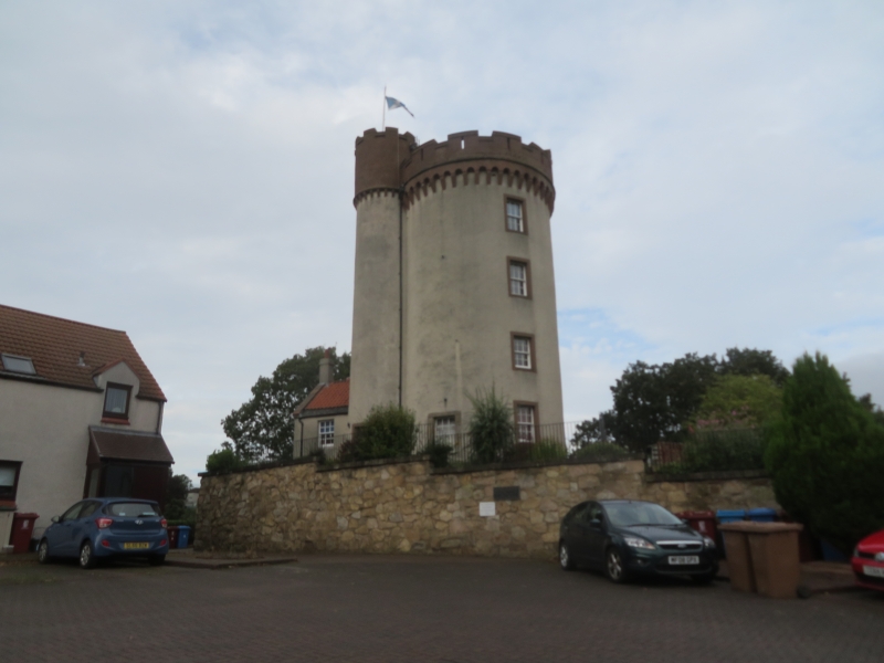
Dated 1750. 4-stage circular tower with basement with attached circular stair-tower and 2-storey pitched roof pantiled wing to S, former windmill with later alterations now converted to house. Harled with predominantly painted margins, base course, brick battlemented and corbelled top storey with arrow slits by Hippolyte Blanc, 1895.
Timber sash and case windows, predominantly 12-pane. Blind window at ground E with unpainted margin and marriage lintel dated 1750 now badly weathered.
INTERIOR: pantiled wing to S has barrel-vaulted ceiling at ground. Tower interior comprehensively modernised.
BOUNDARY WALL: high sandstone rubble wall with flat coping and plaque to E (see Notes).
Sited close to the Antonine Wall the tower is an important and highly prominent landmark in Bo'ness and a very rare, if altered, survival of a windmill. The previous list description for the tower notes that the then door lintel (now a blind window described above) was inscribed '17DS HP50'. This has weathered now and is almost unreadable.
This building has had a varied history and been put to many, some disputable, uses. A corn mill was on the site from the 17th century, and the windmill was built for David Stevenson, shipmaster, and his wife, Helen Paterson. Later, it was used by the local landowners, the Cadell family for the manufacture of sulphuric acid before being converted to an observatory in 1895 by Hippolyte Blanc. The saile and modiner were removed in 1895 to aid the conversion.
The plaque on the boundary wall notes that the building was restored by W A Cadell Architects in 1989 ('Bridgeness Tower Gifted by Grange Estate William A Cadell Architects Restored by John Robertson Builders Ltd Officially opened 8th July 1989 by Provost Dennis Goldie JP').
External links are from the relevant listing authority and, where applicable, Wikidata. Wikidata IDs may be related buildings as well as this specific building. If you want to add or update a link, you will need to do so by editing the Wikidata entry.


Other nearby listed buildings
