Approximate Location Map
Large Map »
Latitude: 56.0009 / 56°0'3"N
Longitude: -2.5141 / 2°30'50"W
OS Eastings: 368036
OS Northings: 678782
OS Grid: NT680787
Mapcode National: GBR ND4V.JZP
Mapcode Global: WH8W0.CF2G
Plus Code: 9C8V2F2P+99
Entry Name: Bamburgh Castle, 23 High Street, Dunbar
Listing Name: 23 High Street, Bamburgh Castle (Through Close of 21-25 High Street)
Listing Date: 5 February 1971
Category: B
Source: Historic Scotland
Source ID: 360840
Historic Scotland Designation Reference: LB24774
Building Class: Cultural
ID on this website: 200360840
Location: Dunbar
County: East Lothian
Town: Dunbar
Electoral Ward: Dunbar and East Linton
Traditional County: East Lothian
Tagged with: Architectural structure
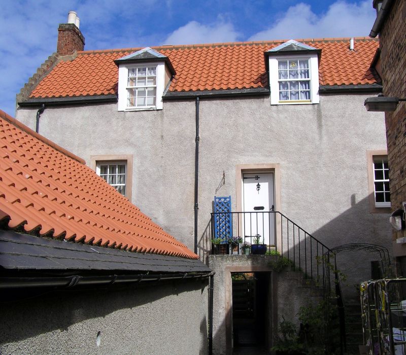
Later 17th century with later alterations. 2-storey and
attic, L-plan house. Harled sandstone rubble with dressed
stone margins. Pantiled roof, slate easing course, crowsteps
and beak skewputts. Harled gable and brick stacks.
Ground floor serving as vaulted cellerage, N part entered
through pend; larger S part now divided, entered from E end
through pend.
W ELEVATION: 4-bay; abutting single storey outbuilding at
right angles, projecting from N bay. Pend under 2nd bay; door
above. L-plan forestair to right with iron railings;
decorative iron door hinges, handle and studs to timber door.
Windows altered, random arrangements, some 12-pane glazing
remains. Modern flat-roofed dormers and earlier piend roofed
dormers breaking eaves.
E ELEVATION: gabled wing to S, possibly later addition with
door below at ground; 2 1st floor windows and small window in
gable head. Stairblock with narrow window in re-entrant angle
under swept roof. Later, lower, lean-to block adjoining to
E. Pend through from main block; windows above and to right
at 1st floor level.
INTERIOR: Modernised above, but some panelled shutters
remaining. Modelled plaster frieze at head of forestair
passage. Early-mid 19th century cast-iron water-spout affixed
to W facade by pend.
Lower walls may incorporate 16th century remains. Tenement
occupies full width of rigg. Originally a tenement of the
Knight's Templar, referred to as Bamburgh Castle, allegedly
with underground passage to Dunbar Castle. Section of Town
Wall remaining to S.
External links are from the relevant listing authority and, where applicable, Wikidata. Wikidata IDs may be related buildings as well as this specific building. If you want to add or update a link, you will need to do so by editing the Wikidata entry.


Other nearby listed buildings
