Approximate Location Map
Large Map »
Latitude: 55.9996 / 55°59'58"N
Longitude: -2.5119 / 2°30'42"W
OS Eastings: 368172
OS Northings: 678633
OS Grid: NT681786
Mapcode National: GBR ND5V.L0L
Mapcode Global: WH8W0.DG3H
Plus Code: 9C7VXFXQ+R7
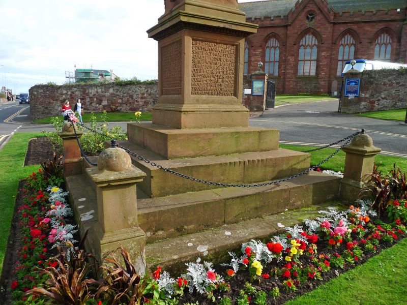
Entry Name: Parish War Memorial, Queen's Road, Dunbar
Listing Name: Queen's Road, Parish War Memorial
Listing Date: 11 January 1988
Category: B
Source: Historic Scotland
Source ID: 360931
Historic Scotland Designation Reference: LB24843
Building Class: Cultural
ID on this website: 200360931
Location: Dunbar
County: East Lothian
Town: Dunbar
Electoral Ward: Dunbar and East Linton
Traditional County: East Lothian
Tagged with: War memorial
C S S Johnston, 1902. Sited by N gate of Parish Church.
Executed by W Grant Stevenson, Corsehill sandstone obelisk
with swags on pedestal and flight of steps. Dedicated to
Lothian and Berwickshire. Yeomanry who fell in South Africa.
External links are from the relevant listing authority and, where applicable, Wikidata. Wikidata IDs may be related buildings as well as this specific building. If you want to add or update a link, you will need to do so by editing the Wikidata entry.


Other nearby listed buildings
