Approximate Location Map
Large Map »
Latitude: 55.923 / 55°55'22"N
Longitude: -3.378 / 3°22'40"W
OS Eastings: 313985
OS Northings: 670846
OS Grid: NT139708
Mapcode National: GBR 21.ZWLH
Mapcode Global: WH6SQ.2DP6
Plus Code: 9C7RWJFC+5R
Entry Name: 18 Baird Road, Ratho, Edinburgh
Listing Name: Ratho Village, 18 Baird Road, Clearence Cottage and Boundary Wall
Listing Date: 8 March 1994
Category: B
Source: Historic Scotland
Source ID: 365031
Historic Scotland Designation Reference: LB27725
Building Class: Cultural
ID on this website: 200365031
Location: Edinburgh
County: Edinburgh
Town: Edinburgh
Electoral Ward: Pentland Hills
Traditional County: Midlothian
Tagged with: Cottage
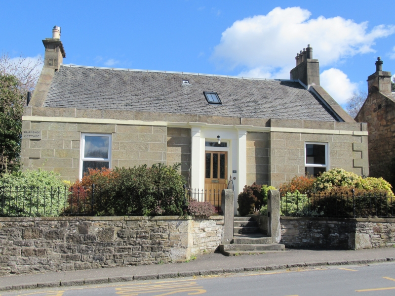
Earlier 19th century. Single storey, 3-bay cottage on falling ground to S with raised basement and attic. Rectangular-plan. Droved ashlar honey-coloured sandstone, rubble to side and rear elevations. Raised ashlar quoins. Blocking course. Band course.
N (MAIN) ELEVATION: door at centre in recessed bay, corniced and pilastered door case, modern door. Windows in flanking bays. Band course runs along base of blocking course.
SIDE ELEVATION: raised basement, 2 low doors at centre with flanking small barred windows. 2 blind windows at 1st floor. Single window in gablehead.
uPVC windows to main elevation, 12-pane sash and case for gablehead window. Grey slate roof, skylight window. ashlar coping to skews. Gablehead stacks (1 corniced, 1 new), circular cans.
BOUNDARY WALL: low rubble wall with slab coping, curves inwards as quadrants at entrance gate. Plain ashlar pedestrian gateposts.
The house is marked on the 1st edition map. This house and the other cottages on Baird Road were the results of improvements carried out by Robert Liston of Millburn Tower who was keen to make Ratho into a model village. The house is listed Category B in consideration of the dwarf walls and obelisk piers, continuous with neighbours.
External links are from the relevant listing authority and, where applicable, Wikidata. Wikidata IDs may be related buildings as well as this specific building. If you want to add or update a link, you will need to do so by editing the Wikidata entry.


Other nearby listed buildings
