Approximate Location Map
Large Map »
Latitude: 55.9509 / 55°57'3"N
Longitude: -3.1684 / 3°10'6"W
OS Eastings: 327133
OS Northings: 673712
OS Grid: NT271737
Mapcode National: GBR 8TG.P8
Mapcode Global: WH6SM.9PGB
Plus Code: 9C7RXR2J+9J
Entry Name: Queen's Drive, St Margaret's Well
Listing Date: 14 December 1970
Category: B
Source: Historic Scotland
Source ID: 365264
Historic Scotland Designation Reference: LB27909
Building Class: Cultural
Also known as: St Margaret's Well, Edinburgh
ID on this website: 200365264
Location: Edinburgh
County: Edinburgh
Town: Edinburgh
Electoral Ward: City Centre
Traditional County: Midlothian
Tagged with: Architectural structure
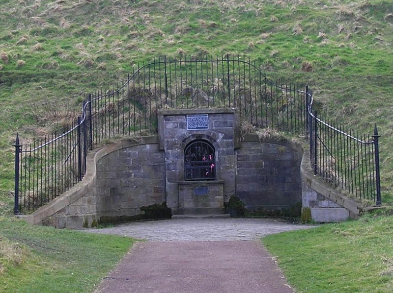
15th century, moved to present site in 1859/60 (see Notes). Hexagonal, rib-vaulted well-house, set into hillside with sweeping symmetrical curvilinear droved stone exterior topped by simple railings. Interior with central pillar and some simple carved bosses. Exterior with central advanced section with round-arched opening with grating leading to well-house. Base course, flat coping. Some damage to bosses and spout.
This interesting and curious 15th century well-house is a miniature representation of the 15th century St Triduana's Aisle in Restalrig (a Scheduled Monument) and is one of 7 wells within the Park. The well is distinguished by its hexagonal chamber and rib-vaulting and its history makes it a remarkable addition to the archaeology of the Park.
The well initially stood in the district of Restalrig, to the East of the Palace, and was a place of pilgrimage because of the spring's medicinal powers. The well was put at risk by the extension of the St Margaret's Workshops of the North British Railway Company in the mid 19th century. Taken apart stone by stone it was relocated by the Society of Antiquaries of Scotland in 1859/60 to its present position over the site of St David's Well. A stone and plaque mark the site of the original well.
With the exception of the occupied buildings, including the lodges, the Park is scheduled under the Ancient Monuments and Archaeological Areas Act 1979. It should be recognised that significant upstanding and below-ground archaeological remains may survive here as part of and in addition to the structures and features described above.
List description revised as part of the Edinburgh Holyrood Ward resurvey 2007-08. Category changed from A to B, 2008.
External links are from the relevant listing authority and, where applicable, Wikidata. Wikidata IDs may be related buildings as well as this specific building. If you want to add or update a link, you will need to do so by editing the Wikidata entry.


Other nearby listed buildings
