Approximate Location Map
Large Map »
Latitude: 55.9482 / 55°56'53"N
Longitude: -3.1919 / 3°11'30"W
OS Eastings: 325660
OS Northings: 673437
OS Grid: NT256734
Mapcode National: GBR 8NH.Y7
Mapcode Global: WH6SL.YR6D
Plus Code: 9C7RWRX5+76
Entry Name: George IV Bridge, Edinburgh
Listing Name: George IV Bridge with Railings
Listing Date: 14 December 1970
Category: A
Source: Historic Scotland
Source ID: 365313
Historic Scotland Designation Reference: LB27942
Building Class: Cultural
ID on this website: 200365313
Location: Edinburgh
County: Edinburgh
Town: Edinburgh
Electoral Ward: City Centre
Traditional County: Midlothian
Tagged with: Bridge Road bridge
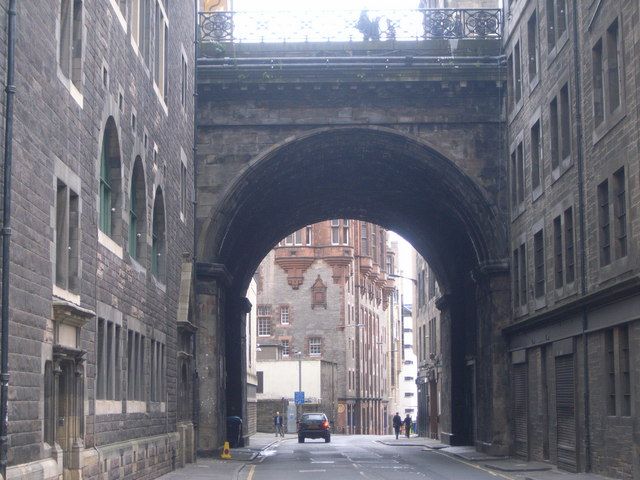
Thomas Hamilton, 1829-34. Multi-arched bridge on piers, built up on both sides, carrying roadway and pavement from Bank Street to Forrest Road/Bristo Place. Ashlar. Visible spans at Cowgate and Merchant Street. At Cowgate: semicircular groin-vaulted arch on chamfered oblong piers, the spaces between now blocked (see Notes); moulded capitals and arch; modillioned entablature; at Merchant Street: semieliptical tunnel arch with flanking segmental pavement arches.
RAILINGS: cast-iron railings with anthemion quartefoils (replaced beside National Library by stone balusters).
A photograph of circa 1860 shows the spaces between the piers of the Cowgate arch open. King George IV Bridge was part of Thomas Hamilton's plan for the new Southern Approach. The plan was first proposed in an article in the Scots Magazine in 1817 (attributed to Hamilton) proposing the formation of 'a Communication between the N and S sides of the City of Edinburgh by means of a bridge entering the Lawnmarket nearly opposite Bank Street.' Hamilton and William Burn produced a 'Report relative to the proposed approaches' in 1824, of which a plan appeared in 'The Scotsman' (27th November 1824). Hamilton and Burn went to London in 1825 to gain support for an Act of Parliament, and the City Improvement Act was passed in 1827. Hamilton was appointed architect to the Commissioners, and carried out the 2 major town planning initiatives for which they were responsible - the W approach - King's Bridge and Johnstone Terrace, and the S approach - George IV Bridge, and the link to the Grassmarket - Victoria Street. Hamilton was replaced as architect to the Commissioners in 1834 by George Smith. Memorial plaque to James Connolly (born at 107 Cowgate) on SE pier.
External links are from the relevant listing authority and, where applicable, Wikidata. Wikidata IDs may be related buildings as well as this specific building. If you want to add or update a link, you will need to do so by editing the Wikidata entry.


Other nearby listed buildings
