Approximate Location Map
Large Map »
Latitude: 55.9083 / 55°54'29"N
Longitude: -3.2565 / 3°15'23"W
OS Eastings: 321544
OS Northings: 669065
OS Grid: NT215690
Mapcode National: GBR 87Y.VJ
Mapcode Global: WH6SR.YRFJ
Plus Code: 9C7RWP5V+89
Entry Name: Spylaw Street Bridge, Edinburgh
Listing Name: Spylaw Street and Dell Road Bridge
Listing Date: 19 November 2003
Category: B
Source: Historic Scotland
Source ID: 365322
Historic Scotland Designation Reference: LB27951
Building Class: Cultural
ID on this website: 200365322
Location: Edinburgh
County: Edinburgh
Town: Edinburgh
Electoral Ward: Colinton/Fairmilehead
Traditional County: Midlothian
Tagged with: Road bridge
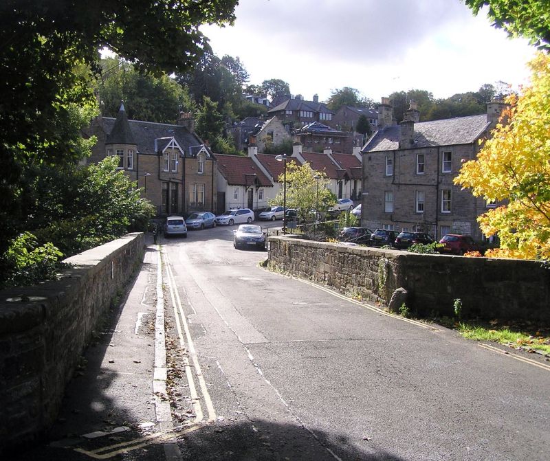
Probably later 18th century, plain single elliptical-arched bridge over the Water of Leith; E parapet wall splayed out at ends, with pall stones at corners; pyramidal caps at ends of parapet walls. Squared sandstone random rubble with flat cope stones to parapet wall and smooth voussoirs.
This bridge contributes greatly to the picturesqueness of Colinton Dell and links the commercial and residential area of old Colinton to St Cuthbert's church. It is very difficult to date a bridge of this type, as construction methods remained relatively unchanged for several centuries. There was definitely a stone bridge here in 1666, for Sir James Turner, who was captured by the Covenanters, mentions in his memoirs that they camped by it on their way to Edinburgh (see Gladstone-Millar). The bridge is also shown on John Adair's Map of Midlothian, 1682. However, it is very unlikely that the present bridge dates back to the seventeenth century. According to Professor Ted Ruddock, the original bridge would have been a narrow pedestrian bridge, and the width of the present bridge suggests a late eighteenth century date. A bridge with splayed ends is shown on the 1771 map of James Gillespie's farm, and it seems likely that that is the present bridge. Professor Ruddock also noted that the bridge seems to have been widened, probably in the late eighteenth, or early nineteenth century.
External links are from the relevant listing authority and, where applicable, Wikidata. Wikidata IDs may be related buildings as well as this specific building. If you want to add or update a link, you will need to do so by editing the Wikidata entry.


Other nearby listed buildings
