Approximate Location Map
Large Map »
Latitude: 55.9587 / 55°57'31"N
Longitude: -3.2004 / 3°12'1"W
OS Eastings: 325149
OS Northings: 674611
OS Grid: NT251746
Mapcode National: GBR 8MC.6G
Mapcode Global: WH6SL.TH5C
Plus Code: 9C7RXQ5X+FR
Entry Name: 36A Cumberland Street, Edinburgh
Listing Name: 78-86A (Even Nos) Dundas Street, and 36A Cumberland Street, Including Railings
Listing Date: 10 November 1966
Category: A
Source: Historic Scotland
Source ID: 367182
Historic Scotland Designation Reference: LB28721
Building Class: Cultural
ID on this website: 200367182
Location: Edinburgh
County: Edinburgh
Town: Edinburgh
Electoral Ward: City Centre
Traditional County: Midlothian
Tagged with: Architectural structure
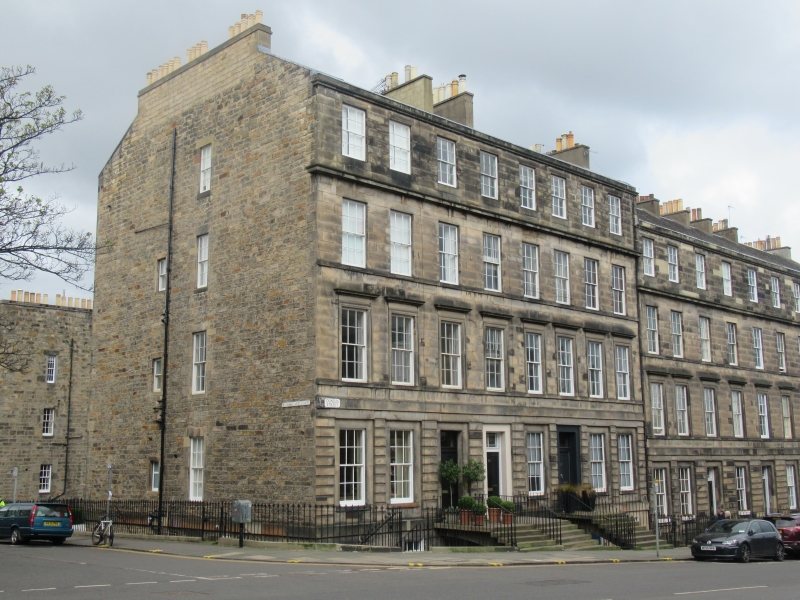
Thomas Bonnar, 1820. 4-storey and basement, 8-bay terraced tenement. Polished ashlar sandstone; V-jointed chanelled rustication at principal floor. Band course at principal and 1st floors; windows at 1st floor with raised margins and cornices; cill course at 1st and 2nd floors; continual cornice at 2nd floor; cornice and blocking course at 3rd floor. Doors and windows of principal floor in square-headed recesses.
E (PRINCIPAL) ELEVATION: 4-panel timber common stair door, with decorative rectangular fanlight, in 4th bay from left at principal floor; 4-panel timber doors with plate glass rectangular fanlight in 3rd bay from left, and with decorative rectangular fanlight in 3rd bay from right. Windows in recesses in remaining bays at principal floor; regular fenestration to floors above, and to basement. Flagged basement area.
N ELEVATION: adjoining terrace, see separate listing (88-102 Dundas Street).
S ELEVATION: predominantly regular-coursed squared rubble gable, becoming 36A Cumberland Street; windows at centre right to all floors, and small lights at centre left, at principal, 1st and 2nd floors. Door at centre right at basement. Flagged basement area.
Predominantly 12-pane timber sash and case windows. Grey slate M-roof. Cast-iron rainwater goods. Rendered ridge stacks, regular-coursed squared rubble gablehead stack with broached quoins; coped, with circular cans.
INTERIORS: not seen, 1997, but some evidence of working panelled shutters.
RAILINGS: ashlar copes surmounted by iron railings with fleur-de-lis balusters and pineapple finials.
Part of the Second New Town A Group, a significant surviving part of one of the most important and best preserved examples of urban planning in Britain.
Dundas Street was part of the first extension to the New Town planned by Reid and Sibbald in 1802. Building began in 1807. Nos 53-97, odd Nos, and Nos 56-102, even Nos (formerly Pitt Street) formed part of the same plan, but building did not start in Pitt street until 1820. 78-86A, even Nos, Dundas Street was originally 18-22B, even Nos, Pitt Street.
External links are from the relevant listing authority and, where applicable, Wikidata. Wikidata IDs may be related buildings as well as this specific building. If you want to add or update a link, you will need to do so by editing the Wikidata entry.


Other nearby listed buildings
