Approximate Location Map
Large Map »
Latitude: 55.9505 / 55°57'1"N
Longitude: -3.1899 / 3°11'23"W
OS Eastings: 325790
OS Northings: 673687
OS Grid: NT257736
Mapcode National: GBR 8PG.BD
Mapcode Global: WH6SL.ZP5N
Plus Code: 9C7RXR26+52
Entry Name: 18-20 Cockburn Street, Edinburgh
Listing Name: 18 and 20 Cockburn Street
Listing Date: 12 December 1974
Category: B
Source: Historic Scotland
Source ID: 370854
Historic Scotland Designation Reference: LB30087
Building Class: Cultural
ID on this website: 200370854
Location: Edinburgh
County: Edinburgh
Town: Edinburgh
Electoral Ward: City Centre
Traditional County: Midlothian
Tagged with: Tenement
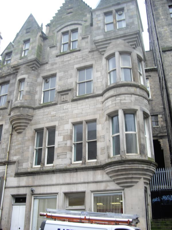
Peddie and Kinnear, Architects, 1859-61. 3-storey and attic tenement with shop to ground floor; circular tower corbelled out at 1st floor to corner of Craig's Close, corbelled to square caphouse with pavilion roof at attic; smaller tower corbelled out at 2nd floor to outer left, corbelled to gabled square at attic; crowstepped gable between. Ashlar to ground floor, squared and snecked lightly stugged sandstone with polished dressings above. Moulded corbel table to 1st floor (linked to elevation of No 24 to left). Moulded string course beneath 2nd floor windows stepping up over date panel (1860). Roll-moulded surrounds to ground floor openings, stop-chamfered above. 2 mullioned bipartite widows to 1st floor; mullioned bipartite in segmental-arched recess in gable. Crowstepped gable with apex stack to Craig's Close.
Plate glass windows to ground floor windows and fanlights; plate glass in timber sash and case windows above. Grey slates.
A Group comprises 1-63 (Odd Nos) and 2-6 and 18-56 (Even Nos) Cockburn Street. Known briefly as Lord Cockburn Street, Cockburn Street was named after the doyen of conservationists, Lord Cockburn, who died in 1854. Cockburn Street was built by the High Street and Railway Station Access Company, under the Railway Station Acts of 1853 and 1860, to provide access to Waverley Station from the High Street. The serpentine curve of the street (anticipated in Thomas Hamilton's Victoria Street) gives a gradient of not more than 1:14; James Peddie and Henry J Wylie were the engineers. One of the aims of the design was to conceal the diagonal line of the street from Princes Street. A watercolour perspective drawing of the street by John Laing, published in THE BUILDER of 1860, shows how this was to be achieved. Stylistically, the intention was 'to preserve as far as possible the architectural style and antique character of the locality.'
External links are from the relevant listing authority and, where applicable, Wikidata. Wikidata IDs may be related buildings as well as this specific building. If you want to add or update a link, you will need to do so by editing the Wikidata entry.


Other nearby listed buildings
