Approximate Location Map
Large Map »
Latitude: 55.547 / 55°32'49"N
Longitude: -2.8419 / 2°50'30"W
OS Eastings: 346978
OS Northings: 628467
OS Grid: NT469284
Mapcode National: GBR 84L9.JC
Mapcode Global: WH7WV.9TZY
Plus Code: 9C7VG5W5+R6
Entry Name: Pant Well, Market Place, Selkirk
Listing Name: Market Place, Pant Well
Listing Date: 12 March 1971
Category: B
Source: Historic Scotland
Source ID: 386516
Historic Scotland Designation Reference: LB40568
Building Class: Cultural
ID on this website: 200386516
Location: Selkirk
County: Scottish Borders
Town: Selkirk
Electoral Ward: Selkirkshire
Traditional County: Selkirkshire
Tagged with: Stone cross
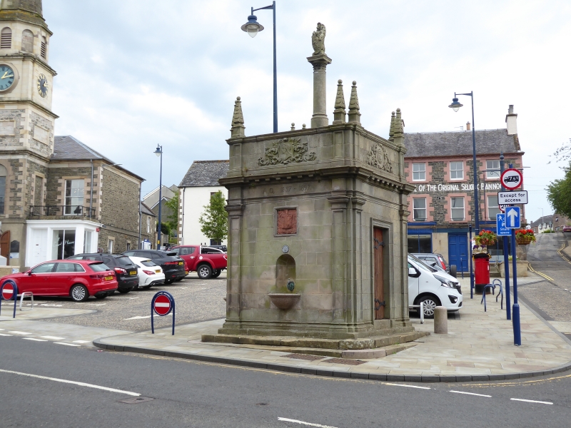
Peddie and Washington Browne, 1898, possibly incorporating earlier fabric. Sandstone ashlar. Square-plan, each elevation with base course, panelled pilasters, architrave, frieze and mutuled cornice with coped parapet above with obelisk finials to each corner; crocket- capitalled shaft to centre above, supporting carved lion clasping shield.
NW ELEVATION: round-arched niche with lion-headed tap and granite bowl to centre. Square plaque above with red sandstone carved heraldic shield. "AD 1837-1897" carved to frieze; portrait of Victoria in shield with acanthus foliate carving to parapet above.
NE ELEVATION: bowed base course to centre with bowed granite horse trough. Bronze plaque above commemorating members of Selkirk Detachment Border Rifles who fought in Boer War (1900-03); town emblem with foliate carving to parapet.
SE ELEVATION: blank except heraldic shield to parapet.
SW ELEVATION: 2-leaf boarded door to centre; heraldic shield with foliate carving to parapet above.
According to Strang, there was an ancient market cross and tollbooth in the Market Place, subsequently demolished in 1765. It has been suggested that the present structure incorporates part of the original cross shaft. Apparently a Pant was an overflow trough for a well.
External links are from the relevant listing authority and, where applicable, Wikidata. Wikidata IDs may be related buildings as well as this specific building. If you want to add or update a link, you will need to do so by editing the Wikidata entry.


Other nearby listed buildings
