Approximate Location Map
Large Map »
Latitude: 58.2094 / 58°12'33"N
Longitude: -6.383 / 6°22'58"W
OS Eastings: 142641
OS Northings: 932887
OS Grid: NB426328
Mapcode National: GBR B7M0.WM9
Mapcode Global: WGY2Y.XXNH
Plus Code: 9CCM6J58+QQ
Entry Name: Museum, Francis Street, Stornoway, Lewis
Listing Name: Francis Street, Museum (Formerly Free Church Seminary and School Building)
Listing Date: 1 February 1993
Category: B
Source: Historic Scotland
Source ID: 388023
Historic Scotland Designation Reference: LB41689
Building Class: Cultural
Also known as: Museum nan Eilean
ID on this website: 200388023
Location: Stornoway
County: Na h-Eileanan Siar
Town: Stornoway
Electoral Ward: Steòrnabhagh a Deas
Traditional County: Ross-shire
Tagged with: Architectural structure Museum building
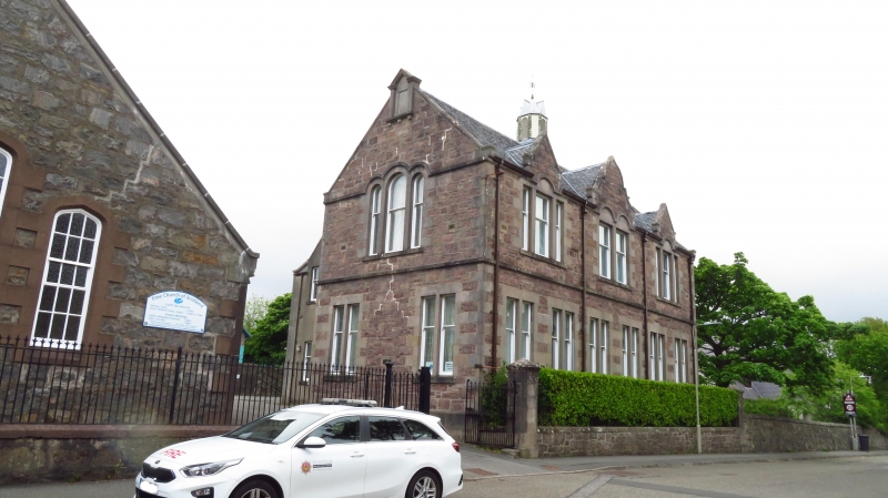
Free church seminary, comprising 2 different blocks, both fronting Francis Street.
BLOCK TO LEFT (nearest west) is a single storey with Tudor-arched windows, possibly a church now in re-use. Rubble-built; rendered dressings, resembling red ashlar, possibly a late 19th century addition to what appears to be a mid 19th century building. Slate roofs. Gabled front to street with 3 stepped windows, small-paned glazing, projecting chimney breast on west flank. Gabled jamb at north end of west flank, main roof carried over porch in re-entrant angle; projecting gable on east flank an addition in sympathetic style.
BLOCK TO RIGHT (nearest east) on corner with Matheson Road, long flank wall to Francis Street. 2-storeyed, gabled, imported brown (?Loch Broom) rubble, contrasting detail in concrete. Slate roof. Mullioned windows, 6 close- spaced bipartited at ground, 3-2-3-light windows at 1st floor, each with gabled head rising above eaves and arch detail to window heads. Axial ventilator cut down - only base survives.
All set behind low boundary wall topped with simple, spiked cast-iron railings.
External links are from the relevant listing authority and, where applicable, Wikidata. Wikidata IDs may be related buildings as well as this specific building. If you want to add or update a link, you will need to do so by editing the Wikidata entry.


Other nearby listed buildings
