Approximate Location Map
Large Map »
Latitude: 56.0634 / 56°3'48"N
Longitude: -4.4946 / 4°29'40"W
OS Eastings: 244785
OS Northings: 688426
OS Grid: NS447884
Mapcode National: GBR 0P.PXZW
Mapcode Global: WH3MZ.XVWL
Plus Code: 9C8Q3G74+95
Entry Name: Woodend Lodge, South Avenue, Buchanan Old House
Listing Name: Buchanan Estate, Woodend Lodge
Listing Date: 27 February 1997
Category: C
Source: Historic Scotland
Source ID: 390570
Historic Scotland Designation Reference: LB43915
Building Class: Cultural
ID on this website: 200390570
Location: Kilmaronock
County: West Dunbartonshire
Electoral Ward: Lomond
Parish: Kilmaronock
Traditional County: Dunbartonshire
Tagged with: Lodge
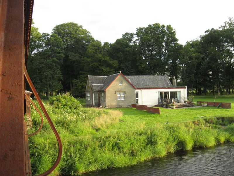
Late 19th century. Single storey and attic asymmetrical, L-plan pair of cottages, made rectangular-plan with later lean-to addition filling re-entrant angle to rear. Squared and snecked sandstone (spalling); one cottage painted. Base course; sandstone mullioned and transomed windows; Tudor hoodmoulds.
E ELEVATION: 3 bays asymmetrically disposed. Broad gable to outer left, canted corniced window, deep base, mullioned window; small windows at centre of gablehead. Narrow gabled porch in re-entrant to right, 4-panelled door with letterbox fanlight. Recessed bay to outer right.
S ELEVATION: 4 bays near-symmetrically disposed. Broad bay to outer right, window with gable breaking eaves above; 3 windows to outer left.
Small 9-paned timber casement windows on sandstone cottage; 4-pane timber windows on painted cottage. Grey slate roof, lead flashings, ashlar coping to skews.
The lodge is located at the end of the S avenue of Buchanan Estate.
A forest lodge is marked on the 1st edition map and Gargowan lodge is shown on the 2nd edition map. The W cottage has been modernised with a flat-roofed extension at rear towards the river. The adjacent bridge over the Endrick water, the S gates and lodge are listed separately. The Buchanan Estate is a designed landscape, most of the estate lies within Stirling Council Area.
External links are from the relevant listing authority and, where applicable, Wikidata. Wikidata IDs may be related buildings as well as this specific building. If you want to add or update a link, you will need to do so by editing the Wikidata entry.


Other nearby listed buildings
