Approximate Location Map
Large Map »
Latitude: 58.9841 / 58°59'2"N
Longitude: -2.9537 / 2°57'13"W
OS Eastings: 345280
OS Northings: 1011164
OS Grid: HY452111
Mapcode National: GBR M42Z.MN4
Mapcode Global: WH7C4.LGP1
Plus Code: 9CCVX2MW+JG
Entry Name: 17 East Road, Kirkwall
Listing Name: 17 East Road, Including Boundary Walls and Railings
Listing Date: 15 March 1999
Category: C
Source: Historic Scotland
Source ID: 393103
Historic Scotland Designation Reference: LB45993
Building Class: Cultural
ID on this website: 200393103
Location: Kirkwall
County: Orkney Islands
Town: Kirkwall
Electoral Ward: Kirkwall East
Traditional County: Orkney
Tagged with: House
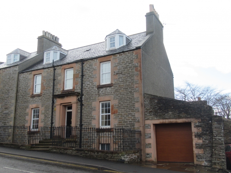
Mid 19th century with later additions. 2-storey, basement and attic, 3-bay rectangular-plan, symmetrical house with piended dormers, built on ground falling to W; abutting Numbers 19 and 21 (listed separately) to left; later lean-to garage, set back to outer right. Squared and coursed rubble with pink sandstone ashlar dressings. Long and short margins to windows; long and short quoins; ashlar steps and entrance platts oversailing basement.
N (PRINCIPAL) ELEVATION: pilastered and corniced doorpiece at ground in bay to centre; deep-set timber-panelled door with rectangular fanlight; window at 1st floor above. Window at basement with window at each floor above with 3-light dormer to attic in each bay flanking. Modern door to garage set back to outer right.
4-pane timber sash and case windows to attic and basement; multi-pane uPVC windows elsewhere. Grey slate roof; stone ridge; stone skews; harled, corniced multi-flue gablehead stack to W; cast-iron rainwater goods.
INTERIOR; not seen, 1998.
BOUNDARY WALLS AND RAILINGS: low rubble boundary walls along north elevation; spear-headed, cast-iron railings, continuous over entrance bridge.
Part of a 19th century development along the south side of East Street, this eastern end being of slightly later date. The symmetrical elevation is enlivened by long and short window margins, original cast-iron railings, and a pilastered and corniced doorpiece.
External links are from the relevant listing authority and, where applicable, Wikidata. Wikidata IDs may be related buildings as well as this specific building. If you want to add or update a link, you will need to do so by editing the Wikidata entry.


Other nearby listed buildings
