Approximate Location Map
Large Map »
Latitude: 55.6587 / 55°39'31"N
Longitude: -3.7631 / 3°45'47"W
OS Eastings: 289174
OS Northings: 641989
OS Grid: NS891419
Mapcode National: GBR 2350.3B
Mapcode Global: WH5SR.5198
Plus Code: 9C7RM65P+FQ
Entry Name: Bonnington Mains
Listing Name: Bonnington Mains
Listing Date: 19 February 2010
Category: B
Source: Historic Scotland
Source ID: 400364
Historic Scotland Designation Reference: LB51427
Building Class: Cultural
ID on this website: 200400364
Location: Lanark
County: South Lanarkshire
Electoral Ward: Clydesdale North
Parish: Lanark
Traditional County: Lanarkshire
Tagged with: Architectural structure
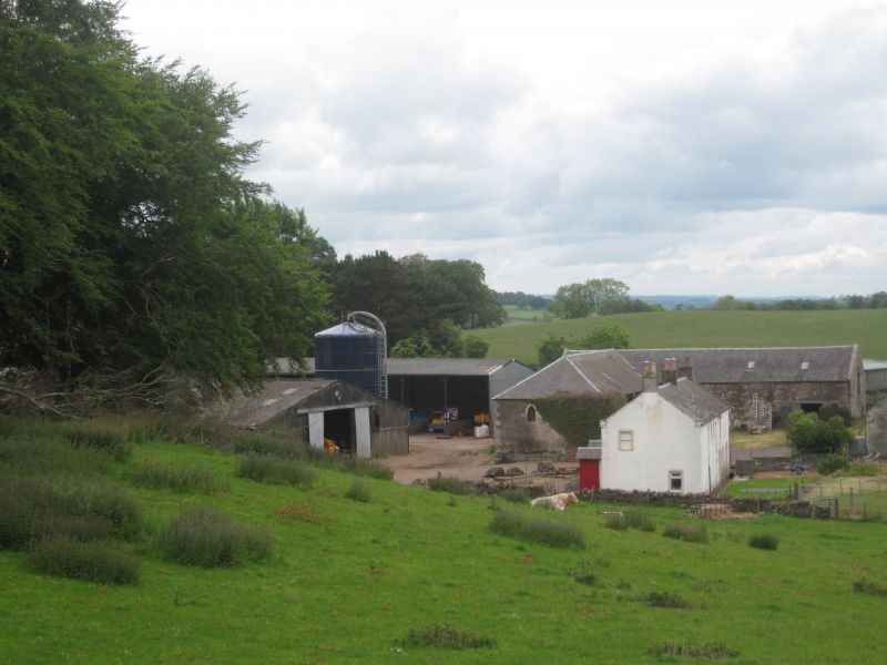
18th century with early 19th century additions. Irregular group of 3 farm buildings forming courtyard: 2-storey, L-plan, threshing barn with hayloft and semi-octagonal horsemill to NW; single-storey, rectangular-plan bothy and stable range to NE; 2-storey, 5-bay, rectangular-plan farmhouse to SE presenting gable to courtyard. Rubble with droved ashlar sandstone dressings to threshing barn, horsemill and steading; farmhouse harled. Pointed arch windows to S gables of barn and stable range; ashlar window margins throughout. Mainly gabled roofs with piended roof to S wing of barn.
THRESHING BARN WITH HORSEMILL: asymmetrically placed door openings to N leg, the one to right with sliding door, with slit window above and square window opening at far right to SE elevation. Open facade with iron columns as implement shed to SW elevation. Opening with 2-leaf timber-boarded door to E gable. Semi-octagonal horse mill projecting to NW with ridge ventilator, rooflights and large opening to E side.
STABLE AND BOTHY RANGE : 7 bays, stable to left, central vehicle shed with sliding door; bothy to right with timber-boarded doors.
INTERIOR: stables with original stalls. Fireplace opening in bothy.
FARMHOUSE: originally two dwellings. Fairly regular fenestration and two projecting porches to SW (front) elevation. Irregular fenestration to rear. Coped gablehead stacks with clay cans.
Some small-pane glazing to steading. Predominantly non-traditional uPVC windows to farmhouse. Ashlar-coped skews to barn and house; squared rubble skews to stable range. Grey slates with zinc ridges.
Bonnington Farm, which was originally the home farm of the Bonnington estate, is fine example of an 18th and early 19th century farm with a rare horse mill.
The farm forms a picturesque group round the court and is unusual for the gothick windows in the S gables of two of the buildings. Horse mills were a common feature of early Improvement Period steadings, their purpose being to operate the threshing machinery. In the early 20th century they were superseded by petrol or diesel operated machines and many horsemill buildings have since fallen into a state of disrepair or have been demolished. This horse mill is a good example in good condition and is also larger than usual.
Bonnington estate passed to Admiral Sir John Lockhart-Ross through his marriage with Lady Ross Baillie in 1757. Admiral Sir John was known to have been a notable estate improver, particularly at another of his estates, Balnagowan, which he inherited in 1754, and he is credited with the construction of Bonnington House. It is likely that he also developed the farm, in particular the farmhouse, the stable and the bothy. Sir John died in 1790, though the estate did not pass to his son immediately as Lady Ross Baillie is recorded as the owner on Forrest's map of 1816. She died in 1817 and, from that time her son, Sir Charles Ross-Lockhart his wife Lady Mary took a keen interest in the development of the estate and implemented many improvements during the period of their tenure. This included the development of paths, rides, view points and buildings and well as planting. The threshing barn and horsemill may date from this period.
The farm appears on both Johnston maps, the first dated 1780 and the other now thought to be late 18th century. The farm is clearly marked on Forrest's map of 1816. However the position of the buildings is hard to marry with map evidence and indeed evidence from the stonework of the buildings indicates various phases of building work and subsequent alterations.
External links are from the relevant listing authority and, where applicable, Wikidata. Wikidata IDs may be related buildings as well as this specific building. If you want to add or update a link, you will need to do so by editing the Wikidata entry.


Other nearby listed buildings
