Approximate Location Map
Large Map »
Latitude: 55.9513 / 55°57'4"N
Longitude: -3.1807 / 3°10'50"W
OS Eastings: 326364
OS Northings: 673770
OS Grid: NT263737
Mapcode National: GBR 8RG.63
Mapcode Global: WH6SM.3PM0
Plus Code: 9C7RXR29+GP
Entry Name: Bible Land, 185, 187 Canongate, Edinburgh
Listing Name: Bible Land, 183-187 (Odd Numbers) Canongate, Edinburgh
Listing Date: 14 December 1970
Last Amended: 17 July 2015
Category: B
Source: Historic Scotland
Source ID: 405352
Historic Scotland Designation Reference: LB28434
Building Class: Cultural
ID on this website: 200405352
Location: Edinburgh
County: Edinburgh
Town: Edinburgh
Electoral Ward: City Centre
Traditional County: Midlothian
Tagged with: Tenement
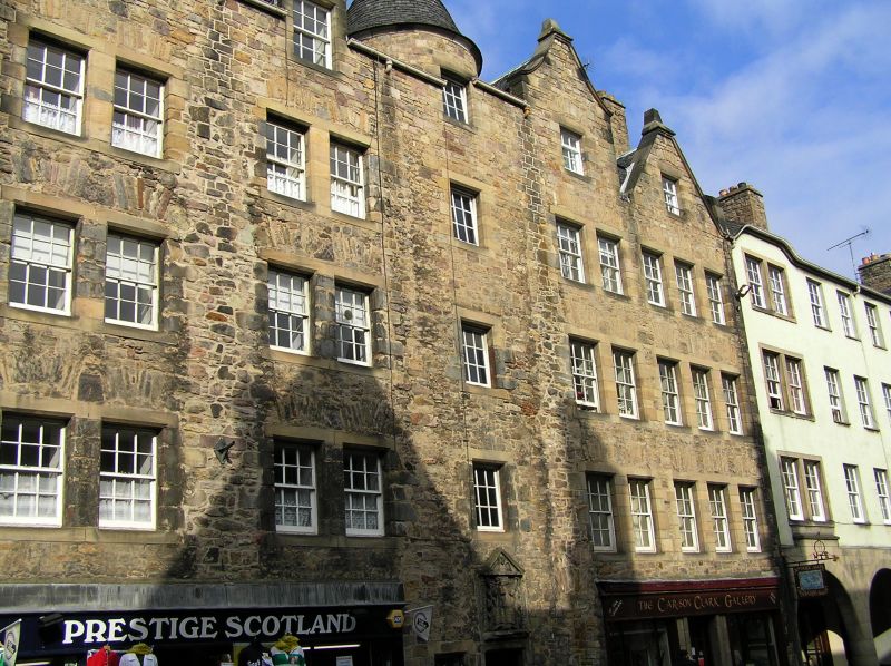
12-pane timber sash and case windows. Scottish slate. Ridge and end stacks. Clay cans. Cast-iron rainwater goods.
'Bible Land' is a fine example of a restored 17th century tenement building. The central, ogee-capped dome and distinctive attic storey as well as the elaborate cartouche set this building apart and contribute much to its character. The shopfronts to left and right are also in keeping with the essential character of the building adding interest to the streetscape.
The substantial restoration by Robert Hurd, who spearheaded the Canongate regeneration project during the 1950s, included the rebuilding of the principal elevation to the same design as the original. The introduction of the pedimented dormer heads to the W side is conjectural.
Bible Land was built for the Incorporation of Cordiners in 1677. The Cordiners or 'Cordovers' were group of artisans who used leather from Cordova in Spain. In the 16th century, there were eight craft incorporations of the Canongate, distinct from those of Edinburgh. The earliest, the hammermen or metalworkers, were established in 1540. The Cordiners followed in 1554, and tailors later in the same year.
The pedimented cartouche, dated 1677, depicts the Cordiners' emblem, the shoemaker's knife, flanked by cherubs'' heads and an open book inscribed 'Behold how good a thing it is and how becoming well, Together such as brethren are in unity to dwell' taken from Psalm 133.
The historic and architectural value of Edinburgh's Canongate area as a whole cannot be overstated. Embodying a spirit of permanence while constantly evolving, its buildings reflect nearly 1000 years of political, religious and civic development in Scotland. The Canons of Holyrood Abbey were given leave by King David I to found the burgh of Canongate in 1140. Either side of the street (a volcanic ridge) was divided into long, narrow strips of land or 'tofts'. By the end of the 15th century all the tofts were occupied, some subdivided into 'forelands' and 'backlands' under different ownership. Fuedal superiority over Canongate ceased after 1560. The following century was a period of wide-scale rebuilding and it was during this time that most of the areas' mansions and fine townhouses were constructed, usually towards the back of the tofts, away from the squalor of the main street. The 17th century also saw the amalgamation of the narrow plots and their redevelopment as courtyards surrounded by tenements. The burgh was formally incorporated into the City in 1856.
Throughout the 19th Century the Canongate's prosperity declined as large sections of the nobility and middle classes moved out of the area in favour of the grandeur and improved facilities of Edinburgh's New Town, a short distance to the North. The Improvement Act of 1867 made efforts to address this, responding early on with large-scale slum clearance and redevelopment of entire street frontages. A further Improvement Act (1893) was in part a reaction to this 'maximum intervention', responding with a programme of relatively small-scale changes within the existing street pattern. This latter approach was more consistent with Patrick Geddes' concept of 'conservative surgery'. Geddes was a renowned intellectual who lived in the Old Town and was a pioneer of the modern conservation movement in Scotland which gathered momentum throughout the 20th century. Extensive rebuilding and infilling of sections of the Canongate's many tenements took place, most notably by city architects, E J McRae and Robert Hurd (mid 20th century) with some early frontages retained and others rebuilt in replica.
List description updated at resurvey (2007/08).
Statutory address updated (2015). Previously listed as '183-187 (odd nos) Canongate, 'Bible Land'.
External links are from the relevant listing authority and, where applicable, Wikidata. Wikidata IDs may be related buildings as well as this specific building. If you want to add or update a link, you will need to do so by editing the Wikidata entry.


Other nearby listed buildings
