Approximate Location Map
Large Map »
Latitude: 53.0317 / 53°1'54"N
Longitude: -3.5049 / 3°30'17"W
OS Eastings: 299175
OS Northings: 349331
OS Grid: SH991493
Mapcode National: GBR 6J.F13G
Mapcode Global: WH66N.4284
Plus Code: 9C5R2FJW+M2
Entry Name: The Crown Inn and stable building
Listing Date: 17 February 1988
Last Amended: 1 April 1998
Grade: II
Source: Cadw
Source ID: 268
Building Class: Domestic
Also known as: Crown Inn
Crown Inn, Corwen
ID on this website: 300000268
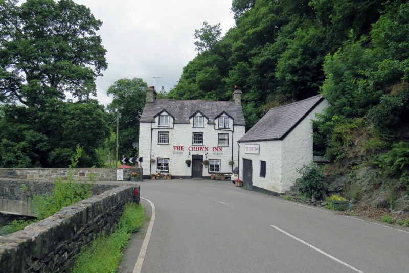
Location: The inn is dramatically set under a crag on the bank of the Afon Alwen close to the NE side of Llanfihangel Bridge, where the road takes a sharp corner on the route to Ruthin.
County: Conwy
Community: Llanfihangel Glyn Myfyr
Community: Llanfihangel Glyn Myfyr
Locality: Llanfihangel
Traditional County: Denbighshire
Late C18 or early C19 hostelry.
Whitewashed rubble stone with later gabled dormers. Two storeys and attic, slate roofs with rubble end stacks. Three window bays. Brick dormers with 2-light casement, 12-pane sash windows with window boxes below (shallow upper sashes). Boarded door in plain surround offset slightly to right, with a plain leaded overlight; blocked opening further right. Short rear service range, rendered, with a later C20 4 x 3 pane window and C20 brick stack.
Detached stable building beside road to the SE of the inn. Slate and whitewashed rubble. Boarded double doors right of centre, and a square boarded ventilation window to the right. External steps at the SE gable end provide access to the loft.
Included as a dramatically situated late C18-early C19 roadside hostelry, and for group value with Pont Llanfihangel.
External links are from the relevant listing authority and, where applicable, Wikidata. Wikidata IDs may be related buildings as well as this specific building. If you want to add or update a link, you will need to do so by editing the Wikidata entry.


Other nearby listed buildings
