Approximate Location Map
Large Map »
Latitude: 53.1774 / 53°10'38"N
Longitude: -3.1314 / 3°7'52"W
OS Eastings: 324480
OS Northings: 365074
OS Grid: SJ244650
Mapcode National: GBR 70.3V5H
Mapcode Global: WH775.WD1H
Plus Code: 9C5R5VG9+XC
Entry Name: Bryn-Yr-Haul
Listing Date: 29 May 1968
Last Amended: 30 March 1987
Grade: II
Source: Cadw
Source ID: 406
Building Class: Domestic
ID on this website: 300000406
Location: Set back from the road in its own grounds approximately a hundred yards from the junction with the A5119.
County: Flintshire
Community: Mold (Yr Wyddgrug)
Community: Mold
Built-Up Area: Mold
Traditional County: Flintshire
Tagged with: Architectural structure
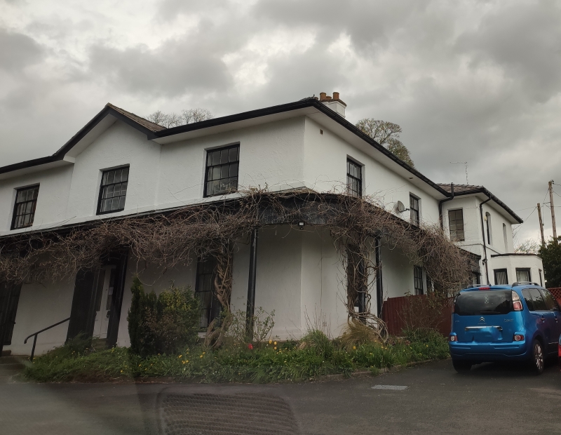
Circa 1840, 2 storey, 3 window. Roughcast on brick, whitewashed. Gently pitched hipped slate roof with eaves soffit. Gable over advanced centre bay, deep verge. Cross plan stacks. Later (?) range with canted bay to rear (right side).
Shallow upper sashes and narrow side panes to 15 pane 1st floor windows. Continuous sill band.
Ground floor, slated verandah on paired slender iron doric columns to SW and SE fronts. Plain valence swept around corners and up over windows. Shallow upper sashes and narrow side panes to deep 25 pane windows; sills rest on ground.
Stone steps to central half-glazed double doors with raised pyramidal panels. 20 pane balanced sashes (narrow side panes) to side elevations. Half glazed side door to SE. Later sashes, to rear range; cambered heads and small panes 1st floor.
Panelled internal shutters.
External links are from the relevant listing authority and, where applicable, Wikidata. Wikidata IDs may be related buildings as well as this specific building. If you want to add or update a link, you will need to do so by editing the Wikidata entry.


Other nearby listed buildings
