Approximate Location Map
Large Map »
Latitude: 53.1131 / 53°6'46"N
Longitude: -3.3157 / 3°18'56"W
OS Eastings: 312031
OS Northings: 358127
OS Grid: SJ120581
Mapcode National: GBR 6R.7YY2
Mapcode Global: WH77H.10CS
Plus Code: 9C5R4M7M+6P
Entry Name: NOS.5 & 7 Mwrog Street, Clwyd
Listing Date: 16 May 1978
Last Amended: 12 July 2006
Grade: II
Source: Cadw
Source ID: 878
Building Class: Commercial
ID on this website: 300000878
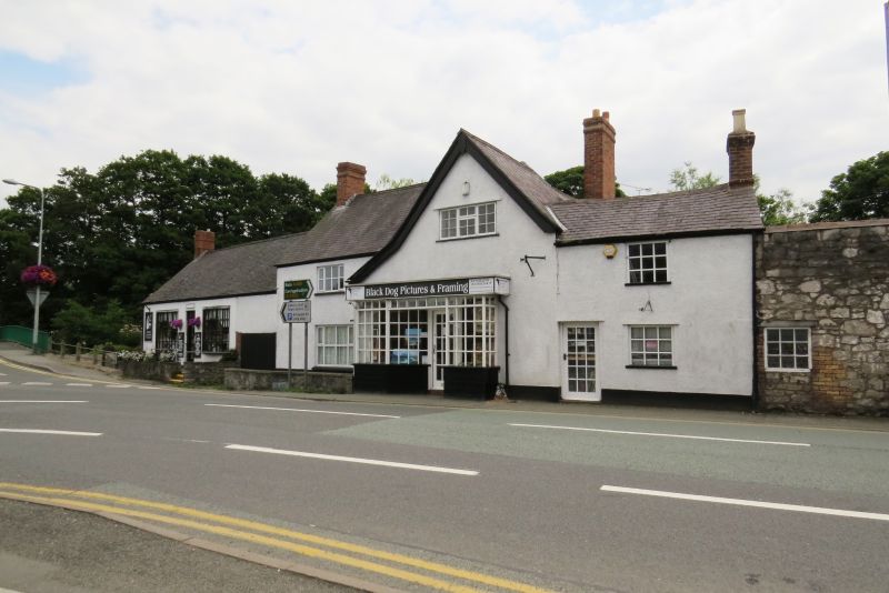
Location: Located at the E end of Mwrog Street, close to the River Clwyd.
County: Denbighshire
Town: Ruthin
Community: Ruthin (Rhuthun)
Community: Ruthin
Locality: Mwrog Street
Built-Up Area: Ruthin
Traditional County: Denbighshire
Tagged with: Building
C17 or earlier, re-fronted in the C19.
5 & 7 form a group
No 5: A 2-storey 2-window range.Rroughcast over timber-framing on a rendered plinth; slate roof, hipped to R end where it adjoins the gabled range of No 7.. Clustered brick end stack to L. Rear wing with large lateral brick stack to its W side. Street-facing elevation has half-glazed panelled door to R (in angle with no 7), under a moulded flat-roofed porch canopy supported on a large rendered post to L. The windows are C20 wooden casements with horizontal glazing bars, a large 4-light window to L of ground floor (possibly a former shop window), and 2 smaller 4-light windows to upper storey. A vehicular through-way to L is in the same range as Nos 1-3, but belongs to No 5. Timber-framing of the original end wall of the dwelling is visible to W side of through-way, with large square panelled framing infilled with stone or brick. Rear elevation is also 2-window with mid-C20 metal casement windows, 2-light to upper storey and single lights to ground floor offset to R. Above through-way to R, a gabled half-dormer with similar window. Rear wing to far L, with current entrance in angle, a lean-to porch against main range, with boarded door facing E and top-hung light to S. Wing is 2-storey, stepping down to L, also with metal casements, 3-light to ground floor, the upper storey with 2-light and single-light windows. Its rear (W) side has similar metal casements. Adjoining to L of front range, a long lofted outbuilding, probably a former carriage shed; it is roughcast under a slate roof with boarded garage doors to R, and 2 large arched openings to L. Inside the arches, the ceiling has shallow-chamfered cross-beams and plain joists. Long brick building extending to L with higher eaves and a ridge stack; several blocked openings, including a possible doorway blocked in stone and a wood-framed window.
Living room to east has a large fireplace with cambered timber lintel. The ceiling has deep-chamfered cross- and spine-beams with hollow-moulded stops and stop-chamfered joists. There was formerly a jetty to W gable end, now encased in No 7, the NW corner supported on a large curved bracket.
Listed as a sub-medieval house, probably of high-status, retaining its plan-form; good C17 interior detail, including ornate ceiling and a jetty to the W end.
External links are from the relevant listing authority and, where applicable, Wikidata. Wikidata IDs may be related buildings as well as this specific building. If you want to add or update a link, you will need to do so by editing the Wikidata entry.


Other nearby listed buildings
