History in Structure

Bridge over Sirhowy River at Gelligroes

A Grade II Listed Building in Pontllanfraith, Caerphilly

More Photos »
Approximate Location Map
Large Map »

Coordinates

Latitude: 51.645 / 51°38'42"N

Longitude: -3.1892 / 3°11'21"W

OS Eastings: 317812

OS Northings: 194694

OS Grid: ST178946

Mapcode National: GBR HX.7JJD

Mapcode Global: VH6DF.NXV9

Plus Code: 9C3RJRW6+28

Entry Name: Bridge over Sirhowy River at Gelligroes

Listing Date: 26 February 1988

Last Amended: 31 March 1999

Grade: II

Source: Cadw

Source ID: 1905

Building Class: Transport

ID on this website: 300001905

Location: Bridge forms part of the S boundary between Pontllanfraith and Ynysddu; adjacent to the mill complex and small hamlet of Gelli-groes; reached by a side road running SE from Newport Road (A4048).

County: Caerphilly

Community: Pontllanfraith (Pontllan-fraith)

Community: Ynysddu

Locality: Gelli-groes

Built-Up Area: Pontllan-fraith

Traditional County: Monmouthshire

Tagged with: Bridge Road bridge

Find accommodation in
Mynyddislwyn

History

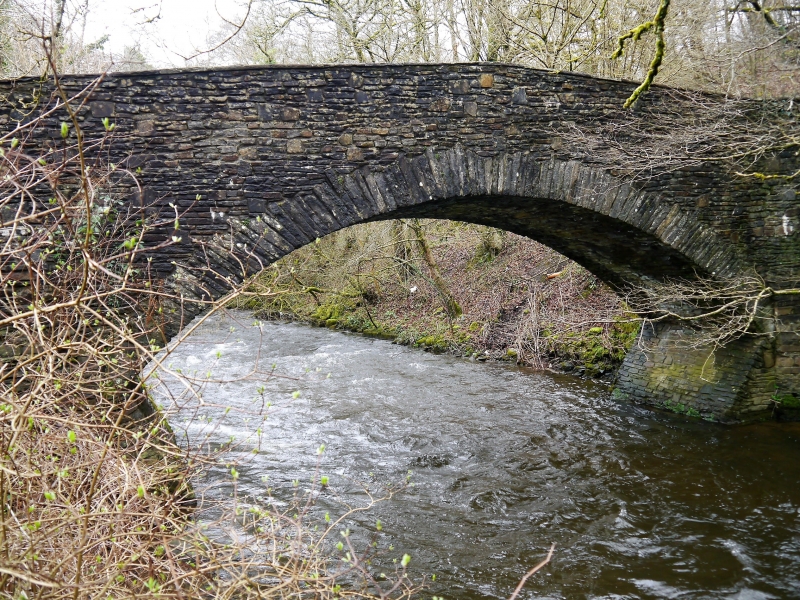
Probably C18. Repaired and repointed 1987. Old photographs show the parapet with railings.

Exterior

Single arch hump-backed bridge of rubble with very deep thin voussoirs to the wide elliptical river arch which is buttressed at river level. Parapets with flat coping stones. Unequal splayed approaches of snecked rubble and part stepped at ground level. Narrow roadway.

Reasons for Listing

Included as a pre-industrial river bridge; group value with the Mill and Mill House at Gelli-groes.

External Links

External links are from the relevant listing authority and, where applicable, Wikidata. Wikidata IDs may be related buildings as well as this specific building. If you want to add or update a link, you will need to do so by editing the Wikidata entry.

Recommended Books

Other nearby listed buildings

  • II* Gelli-groes Mill
    Reached by a side road running SE from Newport Road (A4048); the Mill faces the Sirhowy River and the bridge and is within a grassy enclosure which retains sluices, channelled millrace and tail race,
  • II Gelli-groes Millhouse and attached Barn
    Reached by a side road running SE. from Newport Road (A4048); the Millhouse faces the minor road bridge over the Sirhowy River.
  • II Heather Cottage
    In the centre of the small hamlet of Gelli-groes, on a side road leading off the main Newport Road and almost opposite Siloh chapel.
  • II Pair of chest tombs at Siloh Presbyterian Church
    Close to the front wall of the chapel in the small graveyard fronting the road.
  • II Siloh Presbyterian Church
    In the small hamlet of Gelli-groes, on a side street N of the main Newport Road, set back from the road within a small walled graveyard with houses close on each side.
  • II Stable range at Tyle-gwyn
    To the rear of Tyle-gwyn, built into the hillside.
  • II Tyle-gwyn
    Very near the SW boundary of the community, S of Gelli-groes and above the hamlet of Wyllie; on the hillside reached by a long track.
  • II Shangri-la
    Towards W of the community, on a corner site with Hill Road, set in a sloping garden.

BritishListedBuildings.co.uk is an independent online resource and is not associated with any government department. All government data published here is used under licence. Please do not contact BritishListedBuildings.co.uk for any queries related to any individual listed building, planning permission related to listed buildings or the listing process itself.

British Listed Buildings is a Good Stuff website.