History in Structure

Cross in Churchyard of Church of St. Bartholomew

A Grade II Listed Building in Llanover, Monmouthshire

More Photos »
Approximate Location Map
Large Map »

Coordinates

Latitude: 51.7791 / 51°46'44"N

Longitude: -2.9901 / 2°59'24"W

OS Eastings: 331791

OS Northings: 209399

OS Grid: SO317093

Mapcode National: GBR F6.Z4Y4

Mapcode Global: VH79F.4K30

Plus Code: 9C3VQ2H5+JX

Entry Name: Cross in Churchyard of Church of St. Bartholomew

Listing Date: 9 January 1956

Last Amended: 9 December 2005

Grade: II

Source: Cadw

Source ID: 1993

Building Class: Religious, Ritual and Funerary

Also known as: St. Bartholomew's Churchyard Cross, Llanover

ID on this website: 300001993

Location: On the south side of the church.

County: Monmouthshire

Town: Abergavenny

Community: Llanover (Llanofer)

Community: Goetre Fawr

Locality: Llanover

Traditional County: Monmouthshire

Tagged with: Churchyard cross

Find accommodation in
Llanover

History

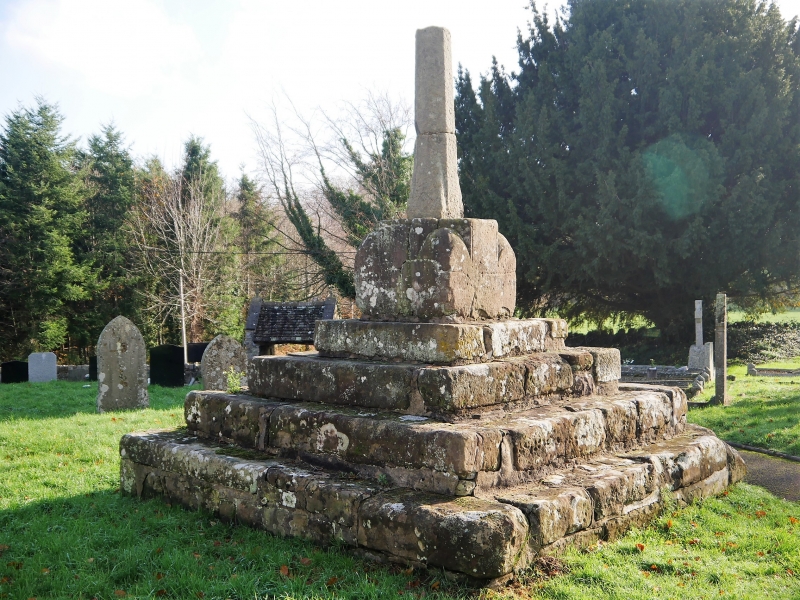
A late medieval, probably late C15, churchyard cross which remains unrestored in its incomplete state. This kind of appearance, so well preserved from the day it was deliberately damaged in the C16 or C17 is now a great rarity.

Exterior

Built of grey and pink sandstone blocks. Four tall square diminishing steps, large broached socket stone, spurred shaft, the cross-head is missing.

Reasons for Listing

Included for its special interest as a probably late medieval churchyard cross of good character which is unrestored and has group value with the adjoining church.

Scheduled Ancient Monument: MM307(MON).

External Links

External links are from the relevant listing authority and, where applicable, Wikidata. Wikidata IDs may be related buildings as well as this specific building. If you want to add or update a link, you will need to do so by editing the Wikidata entry.

Recommended Books

Other nearby listed buildings

  • II* Church of St. Bartholomew
    About 1200m north of Llanover village by the River Usk and on the west side of the minor road from Llanellen to Llanfair Kilgeddin.
  • II Hall Monument
    Set within the Hall monument enclosure against the churchyard wall to the south-west of the church.
  • II Seat at Hall Monument
    Set within the Hall monument enclosure and against the churchyard wall to the south-west of the church.
  • II The Old Schoolhouse
    About 500m south of the Church of St. Bartholomew on the east side of the road from Llanellen to Llanfair Kilgeddin.
  • II The Old School
    About 500m south of the Church of St. Bartholomew on the east side of the road from Llanellen to Llanfair Kilgeddin. The Old School is set back from the road beyond the Old School House.
  • II The Old Rectory
    About 400m north of the Church of St. Bartholomew on the west side of the road from Llanellen to Llanfair Kilgeddin.
  • II Old Stable Block (ruin) at Llanover Park
    In the centre of Llanover Park on the east side of the A4052 and approached via Porth-y-pentre.
  • II Fro Fawr
    About 800 metres ESE of Llanover Church.

BritishListedBuildings.co.uk is an independent online resource and is not associated with any government department. All government data published here is used under licence. Please do not contact BritishListedBuildings.co.uk for any queries related to any individual listed building, planning permission related to listed buildings or the listing process itself.

British Listed Buildings is a Good Stuff website.