Approximate Location Map
Large Map »
Latitude: 51.5784 / 51°34'42"N
Longitude: -2.8096 / 2°48'34"W
OS Eastings: 343995
OS Northings: 186925
OS Grid: ST439869
Mapcode National: GBR JF.CXMD
Mapcode Global: VH7BH.8L1C
Plus Code: 9C3VH5HR+95
Entry Name: Church of St Mary
Listing Date: 19 August 1955
Last Amended: 31 May 1995
Grade: II
Source: Cadw
Source ID: 2052
Building Class: Religious, Ritual and Funerary
Also known as: St Mary's Church, Undy
ID on this website: 300002052
Location: In the centre of the hamlet of Undy, east of Magor.
County: Monmouthshire
Community: Magor with Undy (Magwyr gyda Gwndy)
Community: Magor with Undy
Locality: Undy
Built-Up Area: Undy
Traditional County: Monmouthshire
Tagged with: Church building
Small C12 church, chancel extended later, formerly with central tower which was demolished during major restoration in 1878 and replaced by small bellcote; vestry added NE.
Nave, chancel, south porch. Of rubble with ashlar dressings; nave has roof of small slates and chancel of stone tiles. S ashlar gabled porch with moulded kneelers, coping and apex cross, swept eaves; chamfered arched doorway with inscription to left RI 1790, CW above; inside are stone benches, headstones set in wall, renewed roof; Norman round arched main S doorway with replaced wooden door possibly incorporating earlier metal fittings. S nave has ashlar gabled single bellcote with apex cross; 3 and 2 light C19 trefoil headed S windows; buttress with offsets E. Chancel has ashlar coping, decorative apex cross, moulded kneelers; 2 light trefoil headed S window with moulded stops; pointed chamfered S doorway; 3 cusped light E window under rectangular hood mould substantially renewed. N nave has C19 windows similar to S. W nave has late medieval window of 2 trefoil headed lights separated by diamond mullion under relieving arch; arched doorway with multiple shallow mouldings under heavy hoodmould with weathered face stops and blind tracery panelled reveals; wooden door possibly incorporates earlier metal fittings; shallow corner buttress.
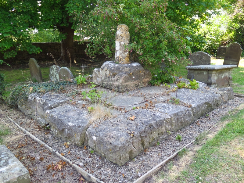
Churchyard retains remains of churchyard cross, with roughly 4m square grass
covered stone base; plinth stone broached into octagon and vestigial octagonal
shaft c 1m high with tracery moulding. Table tomb to Musgrove family with 4
inscription panels 1787, 1800, 1802 and ? 1819 with moulded slab and plinth
incorporating urns in corners on rectangular base. Stone stile to NW.
Heavily restored. C13 pointed chancel arch of 3 orders, the inner with roll moulding and unusually low springing; slender engaged columns with capitals. C12 font on two steps is rectangular with base mouldings and rounded stem with engaged piers. Bell reported as C14 rehung in 1920 with inscription Virgini Marie Laudes.
External links are from the relevant listing authority and, where applicable, Wikidata. Wikidata IDs may be related buildings as well as this specific building. If you want to add or update a link, you will need to do so by editing the Wikidata entry.


Other nearby listed buildings
