Approximate Location Map
Large Map »
Latitude: 51.8783 / 51°52'41"N
Longitude: -2.7902 / 2°47'24"W
OS Eastings: 345700
OS Northings: 220262
OS Grid: SO457202
Mapcode National: GBR FH.RSLH
Mapcode Global: VH794.L19Y
Plus Code: 9C3VV6H5+8W
Entry Name: Skenfrith Castle
Listing Date: 19 November 1953
Last Amended: 19 March 2001
Grade: II*
Source: Cadw
Source ID: 2083
Building Class: Defence
ID on this website: 300002083
Location: Situated at the SE corner of Skenfrith village, in the valley of the River Monnow, close to the W bank of the river and approximately 100m NW of Skenfrith Bridge.
County: Monmouthshire
Town: Monmouth
Community: Llangattock-Vibon-Avel (Llangatwg Feibion Afel)
Community: Skenfrith
Traditional County: Monmouthshire
Tagged with: Castle
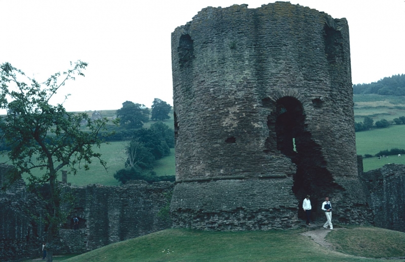
One of three castles granted by King John to Hubert de Burgh in 1201, a powerful marcher lord who became the king's justiciar, who rebuilt it in stone between 1219 and 1232.
Ancient Monument.
A ruined early-C13 curtain-walled castle built of roughly-coursed Old Red Sandstone; formerly surrounded by a moat fed from the river. It has a trapeziform plan, the NE side (to the river) approximately 80m long, the NW and SW sides approximately 60m, and the SE side approximately 40m, with a circular tower at each corner; a semi-circular tower added to the centre of the SW side in the late C13; and a circular keep-tower in the inner ward. Except for a wide breach in the middle of the NW side (now the entrance) the side walls still stand to a height of approximately 4m or 5m, the surviving towers slightly more, but at the NW corner little remains of the corner tower and the walls on either side have been robbed of much of their facing masonry. The original entrance is believed to have been in the middle of the NW side, and there is no other entrance except for a "water gate" in the middle of the NE side, where steps run down from the inner ward to a depressed-arched doorway. The circular keep tower, standing on a low mound offset slightly SW of the centre of the inner ward, is a little over 10m in diameter and about 12m in height. It has a battered plinth approximately 2m high, a former round-headed doorway at 1st-floor level on the N side (the masonry diagonally below it to the right breached); a convex extrusion on the W side (of which only the bottom remains) which appears to have been designed to accommodate a circular stair in the thickness of the wall; and remains of 3 round-headed window openings. Along the inner side of the SW wall are foundations of the basement of the former hall range; and near the NE corner is a circular well.
For further detail, see Pevsner and Newman (2000).
Listed as an important medieval structure. Scheduled Ancient Monument.
External links are from the relevant listing authority and, where applicable, Wikidata. Wikidata IDs may be related buildings as well as this specific building. If you want to add or update a link, you will need to do so by editing the Wikidata entry.


Other nearby listed buildings
