Approximate Location Map
Large Map »
Latitude: 51.8114 / 51°48'41"N
Longitude: -2.7099 / 2°42'35"W
OS Eastings: 351155
OS Northings: 212767
OS Grid: SO511127
Mapcode National: GBR FL.X2FK
Mapcode Global: VH86T.ZQ7R
Plus Code: 9C3VR76R+H2
Entry Name: Wye Bridge
Listing Date: 15 August 1974
Last Amended: 10 August 2005
Grade: II
Source: Cadw
Source ID: 2220
Building Class: Transport
Also known as: Wye Bridge
ID on this website: 300002220
Location: The principal entry to Monmouth from the south and east.
County: Monmouthshire
Town: Monmouth
Community: Monmouth (Trefynwy)
Community: Monmouth
Locality: May Hill
Built-Up Area: Monmouth
Traditional County: Monmouthshire
Tagged with: Road bridge
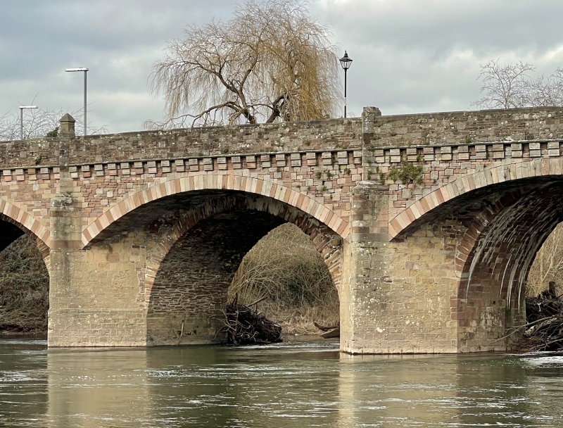
Site of the medieval bridge over the River Wye on east side of town. The present bridge dates from a complete rebuild in 1615, when it had seven spans, according to Coxe, but only five are shown on the Tithe Map of 1843. The bridge was again widened on both sides in 1878-80, architect Edwin Seward of Cardiff (but note inscription), when it was also given corbelled out parapet walls to carry footways. The westernmost arch has been further altered by canted approaches from the A40 dual-carriageway which was built along the river bank between the bridge and the town in 1962.
Built of red and buff sandstone ashlar with much patching. Five arched spans with the original pointed arches visible beneath but with both faces covered by segmental arches carried on the sharply pointed cutwaters. Corbel brackets carry altered parapet walls on either side and there are projecting features with pyramid finials between each arch with an additional one carrying an inscription in the centre of the bridge on the upstream side. The inscription says, 'This bridge was widened 1879 from designs by the County Surveyor, David Roberts Contractor'.
There is a long approach causeway on the east (qv Flood Arches] and the bridge has been slightly shortened on the west end.
Included for its special interest as a handsome historic bridge at an important river crossing.
External links are from the relevant listing authority and, where applicable, Wikidata. Wikidata IDs may be related buildings as well as this specific building. If you want to add or update a link, you will need to do so by editing the Wikidata entry.


Other nearby listed buildings
