Approximate Location Map
Large Map »
Latitude: 51.5912 / 51°35'28"N
Longitude: -2.7466 / 2°44'47"W
OS Eastings: 348374
OS Northings: 188304
OS Grid: ST483883
Mapcode National: GBR JJ.BV4Z
Mapcode Global: VH87Z.B8VJ
Plus Code: 9C3VH7R3+F9
Entry Name: Court House
Listing Date: 28 October 1976
Last Amended: 8 August 2000
Grade: II
Source: Cadw
Source ID: 2739
Building Class: Domestic
ID on this website: 300002739
Location: About 300m south-east of Caldicot village centre approached off Chepstow Road
County: Monmouthshire
Town: Newport
Community: Caldicot
Community: Caldicot
Built-Up Area: Cil-y-coed
Traditional County: Monmouthshire
Tagged with: House
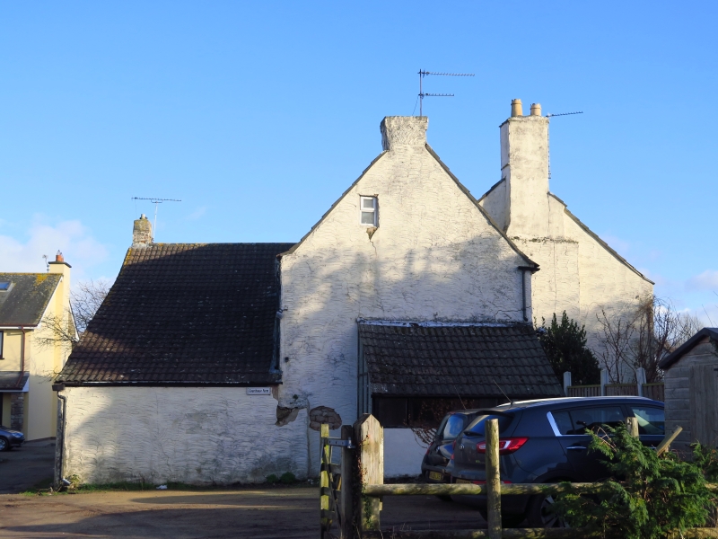
A house probably C16 in origin with C17 and later alterations. It began probably as a 2-cell house with cross passage but the evidence for this is now confused and the entrance leads to a stairhall which will probably be a c1700 alteration although the stair itself is C19. The evidence was further confused by a bad fire in December 1975. The house was bought by Henry Jones of Bristol in 1864 and the bakehouse at the rear is traditionally where he invented self-raising flour, but this cannot be so as the idea was patented in 1846 from Bristol. The invention dramatically improved the quality of bread available to the armed forces, and its success enabled Jones to retire to Caldicot.
Built of rendered rubble with quoins now painted over and with a modern green concrete pantile gabled roof, which was relatively new when inspected for listing in December 1975. Two storeys, with the front elevation roughly of two bays with a central doorway doorway. C19 timber mullioned casements, one to right hand on the ground floor and two of 4-lights each on the first floor, the left hand one in particular is evidently in the original opening. To left hand on the ground floor a modern timber casement. Original doorway with chamfered pointed arch and old ledged door. Modern porch. Gabled roof with end ridge stacks, the left hand stack projecting in the form of a breast, the right hand one rebuilt. Additional wing to the left with a similar window on each floor, gable chimney and garret window, small lean-to on the gable. Rear kitchen wing with catslide roof and gable chimney, modern features to yard. Small attached bakehouse.
The interior was fully inspected in December 1975 before the house was listed. It was partially inspected on resurvey (ground floor only). The ground floor ceiling beams are boxed in as are the fireplaces, and little can be learned from them. The entrance door leads to a stairhall with an early to mid C19 staircase damaged by fire in 1975. West ground floor room with cupboards with panelled doors (not seen at resurvey). The roof timbers (said to be principal rafter type) were charred when inspected in late December 1975.
Listed as an interesting survival of an C16 house later extended and adapted which, despite alteration, retains a number of ancient features and has an historic association with the inventor of self-raising flour, Henry Jones.
External links are from the relevant listing authority and, where applicable, Wikidata. Wikidata IDs may be related buildings as well as this specific building. If you want to add or update a link, you will need to do so by editing the Wikidata entry.


Other nearby listed buildings
