History in Structure

Telephone Call-box

A Grade II Listed Building in Llangattock-Vibon-Avel, Monmouthshire

More Photos »
Approximate Location Map
Large Map »

Coordinates

Latitude: 51.8778 / 51°52'39"N

Longitude: -2.7898 / 2°47'23"W

OS Eastings: 345726

OS Northings: 220204

OS Grid: SO457202

Mapcode National: GBR FH.RSQK

Mapcode Global: VH794.L2HB

Plus Code: 9C3VV6H6+43

Entry Name: Telephone Call-box

Listing Date: 10 September 1990

Last Amended: 19 March 2001

Grade: II

Source: Cadw

Source ID: 2843

Building Class: Communications

ID on this website: 300002843

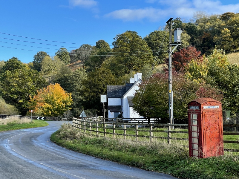
Location: Set into grass verge close to road junction into village; open fields to rear.

County: Monmouthshire

Town: Monmouth

Community: Llangattock-Vibon-Avel (Llangatwg Feibion Afel)

Community: Skenfrith

Traditional County: Monmouthshire

Tagged with: K6 telephone box

Find accommodation in
Skenfrith

History

Design introduced by GPO in 1936; this example dates from the reign of King George VI.

Exterior

K6 type of telephone call box. Cast-iron and glass construction. Square plan. Painted red. Domed roof with four lunettes containing embossed crowns over red lettered opals and ventilation slits. Raised surrounds to sides and door with marginal bars to horizontal glazing. Blank rear, moulded plinth. Foundry plate not visible.

Reasons for Listing

Included for prominent location within Skenfrith conservation area.

External Links

External links are from the relevant listing authority and, where applicable, Wikidata. Wikidata IDs may be related buildings as well as this specific building. If you want to add or update a link, you will need to do so by editing the Wikidata entry.

Recommended Books

Other nearby listed buildings

  • II War Memorial to S of Skenfrith Castle
    Mounted on the roadside approximately halfway between the S end of the village street and Skenfrith Bridge.
  • II Mill House
    On the W side of the junction of the road with the SE end of the village street, facing the plot occupied by Skenfrith Mill.
  • II Skenfrith Mill
    Sited close to the SE corner of Skenfrith Castle, on the SW side of a leet which passes beside the E wall of the castle.
  • II* Skenfrith Castle
    Situated at the SE corner of Skenfrith village, in the valley of the River Monnow, close to the W bank of the river and approximately 100m NW of Skenfrith Bridge.
  • II Skenfrith Bridge
    Crossing the River Monnow approximately 100m E of Skenfrith Castle.
  • II Sarn
    On the W side of the road in the centre of Skenfrith village, facing Skenfrith Castle approximately 50m to the SE.
  • II The Old Shop
    In the centre of Skenfrith village, approximately 50m SE of the Church of St Bridget, with Skenfrith Castle to the front and the church to the rear.
  • I Church of St Bridget
    Very attractively situated towards the N end of the village and approximately 100m NW of Skenfrith Castle, with which it forms part of a very fine group.

BritishListedBuildings.co.uk is an independent online resource and is not associated with any government department. All government data published here is used under licence. Please do not contact BritishListedBuildings.co.uk for any queries related to any individual listed building, planning permission related to listed buildings or the listing process itself.

British Listed Buildings is a Good Stuff website.