Approximate Location Map
Large Map »
Latitude: 51.5817 / 51°34'53"N
Longitude: -3.0009 / 3°0'3"W
OS Eastings: 330745
OS Northings: 187451
OS Grid: ST307874
Mapcode National: GBR J5.CHWD
Mapcode Global: VH7BC.XHXV
Plus Code: 9C3RHXJX+MJ
Entry Name: 11, Friars Road, GWENT
Listing Date: 10 September 1974
Last Amended: 31 March 2000
Grade: II
Source: Cadw
Source ID: 3017
Building Class: Domestic
ID on this website: 300003017
Location: About 50m N of junction with Belle Vue Lane.
County: Newport
Community: Stow Hill
Community: Stow Hill
Built-Up Area: Newport
Traditional County: Monmouthshire
Tagged with: Building
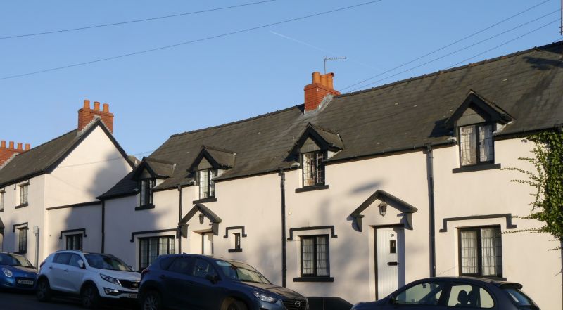
Early-to-Mid C19 house.
One storey plus attic. Stucco, slate roof. Casement glazing throughout. Two gabled dormers. On ground floor, doorway with bracketed hoodmould in form of pediment; modern boarded door; 4-light window to L; small window to R; both windows with hoodmoulds. Extension in matching style (to L) joining with No 9.
Early-to-mid C19 house retaining much of its character. Group value with attached Nos 9 & 13.
External links are from the relevant listing authority and, where applicable, Wikidata. Wikidata IDs may be related buildings as well as this specific building. If you want to add or update a link, you will need to do so by editing the Wikidata entry.


Other nearby listed buildings
