Approximate Location Map
Large Map »
Latitude: 51.7327 / 51°43'57"N
Longitude: -3.0691 / 3°4'8"W
OS Eastings: 326264
OS Northings: 204317
OS Grid: SO262043
Mapcode National: GBR J2.24Q4
Mapcode Global: VH79K.RQB2
Plus Code: 9C3RPWMJ+39
Entry Name: Garndiffaith Railway Viaduct
Listing Date: 16 November 1990
Last Amended: 28 July 1997
Grade: II
Source: Cadw
Source ID: 3151
Building Class: Transport
ID on this website: 300003151
Location: Approximately 250m east of the B4246. Spanning the steep sided valley of the river Ffrwd between the northern part of Talywain and the southern part of Garndiffaith.
County: Torfaen
Town: Pontypool
Community: Abersychan
Community: Abersychan
Locality: Garndiffaith
Built-Up Area: Abersychan
Traditional County: Monmouthshire
Tagged with: Bridge over valley
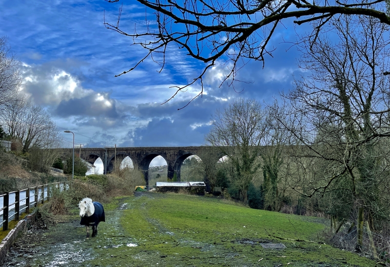
Opened in 1877; built by John Gardner, consultant engineer to the London and North Western Railway for this area. Carried the LNWR at the southern end of their Blaenavon banch which ran south from Brynmawr on the Merthyr,Tredegar and Abergavenny line, meeting the Talywain branch of the Monmouthshire Railway and Canal Company (GWR from 1880). Opened for passenger traffic on 1st May 1878, but also had an important function serving collieries and ironworks in the Abersychan area. As well as the single track branch line it also carried a track leading to the British Ironworks. The line was finally closed in 1965.
An originally twin track railway viaduct. Snecked rubble construction with ashlar impost bands, a vermiculated stringcourse above arches, which have blue brick voussoirs and soffits; stone piers. Nine semi-circular 50' arches, built in equal sections of 3 arches with corbelled refuges on each third pier, and following a gentle curve; the viaduct narrows towards the east end. Chamfered ashlar plaque on the pier by Viaduct Road states 'ERECTED A.D. 1876-7 John Gardner M.Inst C.E. Engineer'. The viaduct is now a cycle track and footpath with fences on either side, and it is beginning to have a cover of vegetation.
Listed for its special interest to the history of the south-east Wales railways, as a good example of a railway viaduct for its period and for its dominant position in the valley.
External links are from the relevant listing authority and, where applicable, Wikidata. Wikidata IDs may be related buildings as well as this specific building. If you want to add or update a link, you will need to do so by editing the Wikidata entry.


Other nearby listed buildings
