History in Structure

Pont Trefriw

A Grade II Listed Building in Trefriw, Conwy

More Photos »
Approximate Location Map
Large Map »

Coordinates

Latitude: 53.151 / 53°9'3"N

Longitude: -3.8244 / 3°49'27"W

OS Eastings: 278087

OS Northings: 363095

OS Grid: SH780630

Mapcode National: GBR 63.5FGW

Mapcode Global: WH65X.7226

Plus Code: 9C5R552G+C6

Entry Name: Pont Trefriw

Listing Date: 13 October 1966

Last Amended: 30 May 1996

Grade: II

Source: Cadw

Source ID: 3220

Building Class: Transport

ID on this website: 300003220

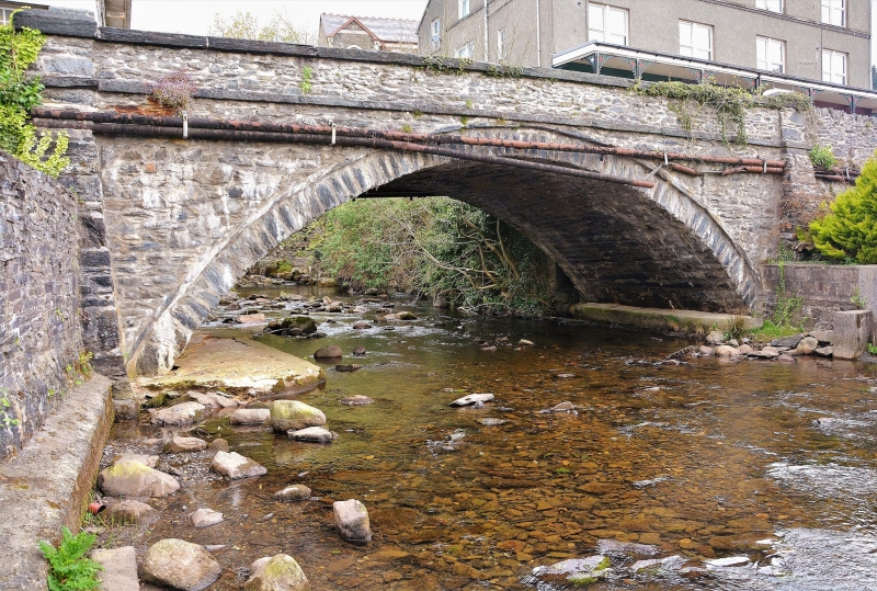
Location: Road bridge in the town centre, spanning the Afon Crafnant.

County: Conwy

Community: Trefriw

Community: Trefriw

Built-Up Area: Trefriw

Traditional County: Caernarfonshire

Tagged with: Bridge

Find accommodation in
Trefriw

Exterior

Late C18 or early C19, and certainly post 1777 when plans for the new turnpike road were formed. Survey plans exist dated 1822, though this need not be the construction date. Wide, single-span rubble bridge with segmental arch; rough-dressed voussoirs recessed slightly below a plain arch ring formed of narrow stones. Parapets with rough-dressed coping stones and plain band below; battered piers flanking the arch. Modern footway added on W side; arch strengthened with modern strutting.

Reasons for Listing

A late C18 or early C19 road bridge in a prominent location within the town.

External Links

External links are from the relevant listing authority and, where applicable, Wikidata. Wikidata IDs may be related buildings as well as this specific building. If you want to add or update a link, you will need to do so by editing the Wikidata entry.

Recommended Books

Other nearby listed buildings

  • II Plas Coch
    On the street line in the town centre, just S of Llys Llewelyn and opposite the Trefriw Hall; set back slightly behind a low wall with simple C19 gates and iron railings.
  • II Trefriw Hall
    Set back from the main street in the town centre, partly obscured by later housing on the street-line in front.
  • II Llys Llewelyn
    Prominently sited in the town centre just S of the church of St. Mary; set back slightly from the road behind a low garden wall with simple spear-headed gates and railings.
  • II Tan-yr-Yw
    On the street line, opposite the church of St. Mary.
  • II Glan-y-Ddol
    On the street line, opposite the church of St. Mary and stepped-down and adjoining Tan-yr-Yw.
  • II Peniel Welsh Presbyterian Chapel
    Strikingly located in the centre of the town, set against the hillside above and to the SW of the parish church; raised up on a revetted and railed terrace with simple gates and gatepiers.
  • II* Parish Church of St. Mary
    Prominently sited in the town centre within a raised, rubble-walled churchyard; on sloping ground, the W end set into a hill.
  • II The Old Rectory
    Located towards the SE edge of the town; occupying a commanding hillside position S of the Afon Crafnant, close to the old Trefriw woollen mills.

BritishListedBuildings.co.uk is an independent online resource and is not associated with any government department. All government data published here is used under licence. Please do not contact BritishListedBuildings.co.uk for any queries related to any individual listed building, planning permission related to listed buildings or the listing process itself.

British Listed Buildings is a Good Stuff website.