Approximate Location Map
Large Map »
Latitude: 53.0939 / 53°5'38"N
Longitude: -3.806 / 3°48'21"W
OS Eastings: 279162
OS Northings: 356711
OS Grid: SH791567
Mapcode National: GBR 63.95Z6
Mapcode Global: WH663.HHVH
Plus Code: 9C5R35VV+HJ
Entry Name: Pont-y-Pair
Listing Date: 21 June 1950
Last Amended: 30 May 1996
Grade: II*
Source: Cadw
Source ID: 3230
Building Class: Transport
Also known as: Pont y Pair
Pont Y Pair
ID on this website: 300003230
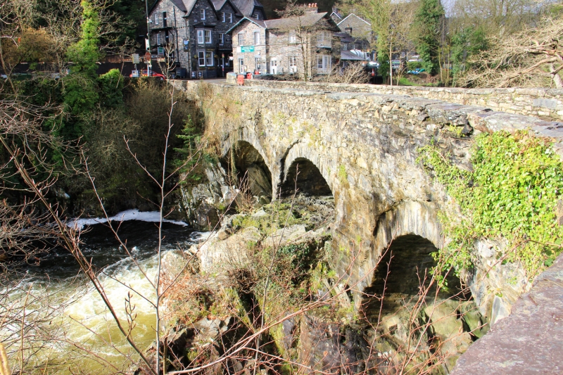
Location: Carrying the B5106 and fording the Afon Llugwy in the centre of the town.
County: Conwy
Community: Betws-y-Coed
Community: Betws-y-Coed
Built-Up Area: Betws-Y-Coed
Traditional County: Caernarfonshire
Tagged with: Road bridge
Early bridge, ascribed to Howell Saer (fl .1468) by Edward Lhwyd writing in 1699. The present fabric is probably C17, widened and partly rebuilt in the late C18 or early C19; the bridge was described by Sir Richard Colt-Hoare in 1797 as the `romantic bridge over the River Llugwy,' and was described in its present form by Richard Fenton in 1810.
5-span rubble bridge of roughly 45m length, originally of roughly 2.5m width, widened to the NW (upstream) side by a further 2.5m. The arches are segmental and of varying widths and heights, some springing directly from the rock. The central, widest one spans the river proper; roughly-dressed voussoirs slightly inset beneath arch-rings formed of narrower stones. Low rubble parapets, splayed at the approaches and with slatestone slab capping.
Graded II* as a dramatically-sited 5-span vernacular bridge with early origins, in a prominent town-centre location.
Scheduled Ancient Monument: CN032
External links are from the relevant listing authority and, where applicable, Wikidata. Wikidata IDs may be related buildings as well as this specific building. If you want to add or update a link, you will need to do so by editing the Wikidata entry.


Other nearby listed buildings
