Approximate Location Map
Large Map »
Latitude: 53.2805 / 53°16'49"N
Longitude: -3.8289 / 3°49'43"W
OS Eastings: 278160
OS Northings: 377507
OS Grid: SH781775
Mapcode National: GBR 1ZPH.VR
Mapcode Global: WH654.4SZZ
Plus Code: 9C5R75JC+6F
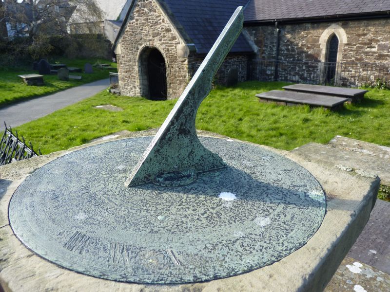
Entry Name: Sundial in St Mary's churchyard
Listing Date: 8 October 1981
Last Amended: 5 May 2006
Grade: II
Source: Cadw
Source ID: 3354
Building Class: Gardens, Parks and Urban Spaces
ID on this website: 300003354
Location: To the S of the nave, opposite the narrow lane leading from Rose Hill Street.
County: Conwy
Town: Conwy
Community: Conwy
Community: Conwy
Locality: Walled town
Built-Up Area: Conwy
Traditional County: Caernarfonshire
Tagged with: Sundial
Dated 1761.
A freestone shaped pedestal on a square base. It has a flat square top with original plate and gnomon. The plate bears the inscription 'Erected by the Corporation of Conway, Robert Wynn, Hugh Williams and John Nuttall Bailiffs, 1761, Meredith Hughes fecit'.
Listed as a rare well-preserved C18 sundial, and for group value with the church and other listed churchyard items.
External links are from the relevant listing authority and, where applicable, Wikidata. Wikidata IDs may be related buildings as well as this specific building. If you want to add or update a link, you will need to do so by editing the Wikidata entry.


Other nearby listed buildings
