Approximate Location Map
Large Map »
Latitude: 53.2306 / 53°13'50"N
Longitude: -4.115 / 4°6'54"W
OS Eastings: 258920
OS Northings: 372479
OS Grid: SH589724
Mapcode National: GBR 5Q.0GVT
Mapcode Global: WH547.R2N6
Plus Code: 9C5Q6VJM+6X
Entry Name: Tan-y-Coed
Listing Date: 27 May 1949
Last Amended: 2 August 1988
Grade: II
Source: Cadw
Source ID: 4097
Building Class: Domestic
ID on this website: 300004097
Location: Elevated above the road with broad views across the Menai Straits; at the W end of the old Holyhead road cutting.
County: Gwynedd
Community: Bangor
Community: Bangor
Locality: Penebryn
Built-Up Area: Bangor
Traditional County: Caernarfonshire
Tagged with: Architectural structure
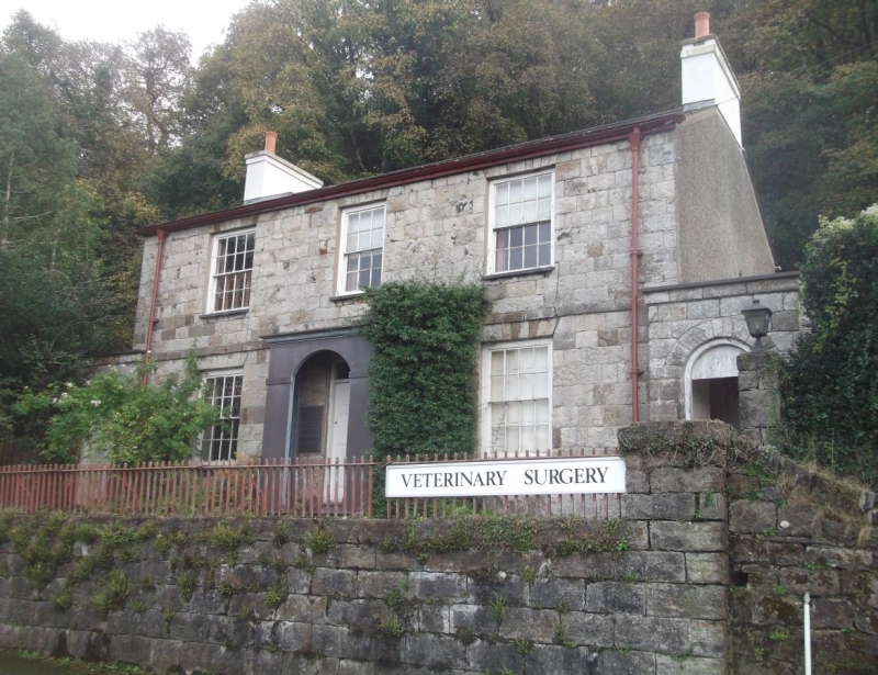
Dated 1810, (opened 25 October). Built by Benjamin Wyatt, architect to Penrhyn Estate, as the Caernarfonshire and Anglesey dispensary; commissioned by Dean Warren. Said to have been converted into a private house in 1847; the right hand cross range had been added by 1854 and the 1987 OS map shows the building much as it is today. In 1960’s it was the office of Howell and Doherty, architects.
2-storey, 3-window coursed rubble symmetrical front with band course over ground floor. Slate roof and rendered end chimney stacks. Small pane sash windows, 16-pane except for that over the porch with parapet and cornice; segmental entrance with 6-panel door; modern inner door. In the porch are 2 slate tablets describing the history of the building, one states that it was sited here to be clearly visible from Anglesey.
Advanced at either end are single storey screen walls with boarded doors in round arched headed entrances giving access to the cross ranges. French windows on the left gable end; right end it scribed rendered. Slate paves courtyard to rear with cross ranges stepped out from gable ends and extending back to Castle Bank. That to the left retains small pane sash windows, including one horizontally sliding; the large pebbledash chimney stack may represent the former extend of this range before enlargement. The right hand range retains the Victorian larder with slate shelving.
Dressed stone gate piers to the front; slate steps and plain iron railings.
Captain Johnson’s 1854 map.
The interior retains 6-panel doors, segmental hallway arch and tightly winding staircase with turned newel. The 1st floor was originally undivided and used as the hospital ward.
Group value with the old road cutting.
External links are from the relevant listing authority and, where applicable, Wikidata. Wikidata IDs may be related buildings as well as this specific building. If you want to add or update a link, you will need to do so by editing the Wikidata entry.


Other nearby listed buildings
