History in Structure

Cottage and Outbuilding, adjoining Fronheulog

A Grade II Listed Building in Llanystumdwy, Gwynedd

More Photos »
Approximate Location Map
Large Map »

Coordinates

Latitude: 52.9446 / 52°56'40"N

Longitude: -4.3408 / 4°20'26"W

OS Eastings: 242809

OS Northings: 341143

OS Grid: SH428411

Mapcode National: GBR 5F.LG0T

Mapcode Global: WH44C.975Y

Plus Code: 9C4QWMV5+RM

Entry Name: Cottage and Outbuilding, adjoining Fronheulog

Listing Date: 19 October 1971

Last Amended: 31 March 1999

Grade: II

Source: Cadw

Source ID: 4346

Building Class: Domestic

ID on this website: 300004346

Location: The short row of cottages stands immediately W of the church and behind Bryn Aber, with the graveyard extension to the rear.

County: Gwynedd

Town: Pwllheli

Community: Llanystumdwy

Community: Llanystumdwy

Locality: Llangybi

Traditional County: Caernarfonshire

Tagged with: Cottage

Find accommodation in
Llangybi

History

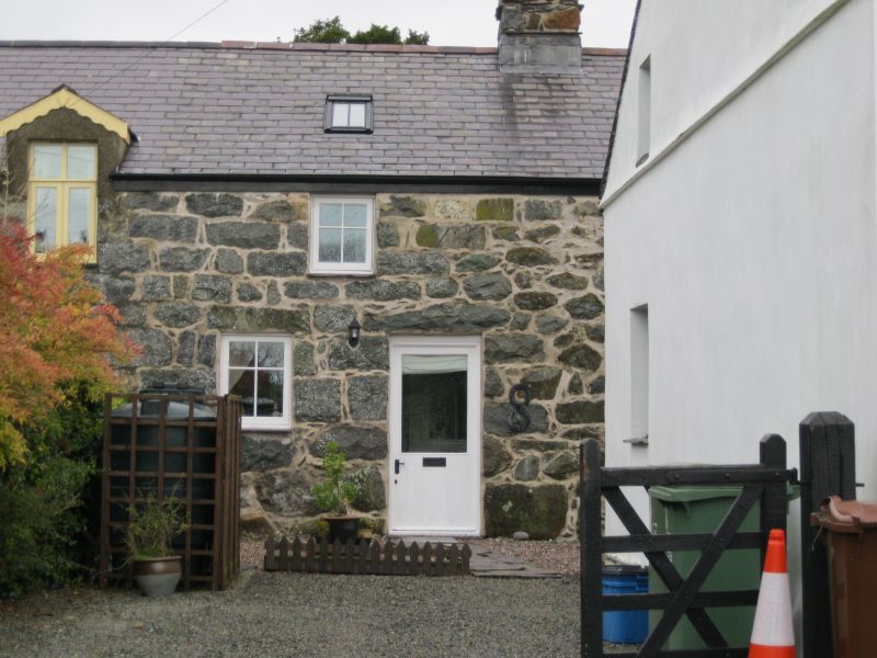
Probably built in the early-mid C19, converting an older building, and forming part of a longer row.

Exterior

Part of a row with Fronheulog to the left and forming small single unit dwelling with outbuilding (perhaps once itself domestic) under one roof. Large rubble stone construction with old slate roof and axial stone stack towards rear of roof slope. Cottage has doorway to right and single window (detail renewed) to its left. Single window unaligned above. Outbuilding beyond has small blocked window to 1st floor; other openings are larger and have later detail.

Reasons for Listing

Included for group value with the church and adjoining buildings at the centre of Llangybi.

External Links

External links are from the relevant listing authority and, where applicable, Wikidata. Wikidata IDs may be related buildings as well as this specific building. If you want to add or update a link, you will need to do so by editing the Wikidata entry.

Recommended Books

Other nearby listed buildings

  • II Fronheulog
    Fronheulog is a short row of two cottages immediately SW of the church, behind Bryn Aber and backing on to the graveyard extension.
  • II Lychgate and Churchyard Wall to the Church of St Cybi
    The churchyard surrounds the church in the centre of Llangybi village. The lychgate is at the W end.
  • II Ty'n-y-porth
    The house lies along the street frontage opposite the church of St Cybi, at the centre of the village.
  • II* Church of St Cybi
    The parish church stands in its churchyard at the centre of the village.
  • II Castell
    The cottage is set back from the road, S of the church and to the E of Ty'n-y-porth.
  • II Elusendai Price (Bryncastell, Berth-lwyd, Daron, Ty-Newydd and Hen Ysgoldy)
    The almshouses lie 100m E of the church within the nucleated centre of Llangybi.
  • I Ffynnon Cybi and associated works
    The well lies in the narrow valley below the slopes of Garn Bentyrch, and is reached by a footpath from the NE corner of the churchyard, crossing two fields, the second by a causeway.
  • II Ty-Hir
    The large farmhouse stands end on to the road, and facing S, on the road which runs NE of Llanarmon village in the direction of Rhosgyll.

BritishListedBuildings.co.uk is an independent online resource and is not associated with any government department. All government data published here is used under licence. Please do not contact BritishListedBuildings.co.uk for any queries related to any individual listed building, planning permission related to listed buildings or the listing process itself.

British Listed Buildings is a Good Stuff website.