Approximate Location Map
Large Map »
Latitude: 52.9177 / 52°55'3"N
Longitude: -4.2873 / 4°17'14"W
OS Eastings: 246313
OS Northings: 338039
OS Grid: SH463380
Mapcode National: GBR 5H.N918
Mapcode Global: WH44D.3XQL
Plus Code: 9C4QWP97+33
Entry Name: Bont Fechan
Listing Date: 19 October 1971
Last Amended: 31 March 1999
Grade: II
Source: Cadw
Source ID: 4365
Building Class: Transport
ID on this website: 300004365
Location: Located on a cut off section of the main A497 Cricieth to Pwllheli road, SE of the village of Llanystumdwy, and formerly carrying the road over the Afon Dwyfor.
County: Gwynedd
Town: Criccieth
Community: Llanystumdwy
Community: Llanystumdwy
Traditional County: Caernarfonshire
Tagged with: Architectural structure
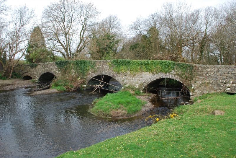
Probably built during the late C17 or early C18, and widened in 1780 on the E side, at which time the S arch and N culvert were reconstructed. Repaired in the 1880s, and finally by-passed in July 1961 by the new Llanystumdwy by-pass.
The bridge consists of three major segmental arches of rubble voussoirs, the earlier on the E flush with the spandrels, the later on the W set back under a regulating course. Each major arch spans 4.3m with a rise of 1.8m above the river level, and supported by two water piers, the S one larger and higher than the more northerly, and each chamfered back to the flush stone parapet, coped with large unshaped stones. At the S end there is a lower segmental flood arch, and at the N end, a small culvert, the whole totalling approximately 24.4m in length (80ft). The bridge was widened by 1.74m on the W side creating a carriageway width over of 3.9m with 0.43m parapets each side.
Included as a good substantial and well-detailed late C17/early C18 county bridge of vernacular character.
External links are from the relevant listing authority and, where applicable, Wikidata. Wikidata IDs may be related buildings as well as this specific building. If you want to add or update a link, you will need to do so by editing the Wikidata entry.


Other nearby listed buildings
