Approximate Location Map
Large Map »
Latitude: 52.9228 / 52°55'22"N
Longitude: -4.135 / 4°8'6"W
OS Eastings: 256563
OS Northings: 338293
OS Grid: SH565382
Mapcode National: GBR 5P.MXPC
Mapcode Global: WH55L.GS5N
Plus Code: 9C4QWVF7+4X
Entry Name: Pen-y-clogwyn, including attached farm building
Listing Date: 1 April 1974
Last Amended: 26 September 2005
Grade: II
Source: Cadw
Source ID: 4406
Building Class: Domestic
ID on this website: 300004406
Location: Reached by a short farm road on the W side of Borth Road approximately 0.5km SW of Porthmadog town centre.
County: Gwynedd
Town: Porthmadog
Community: Porthmadog
Community: Porthmadog
Locality: Pen-y-clogwyn
Built-Up Area: Porthmadog
Traditional County: Caernarfonshire
Tagged with: Agricultural structure
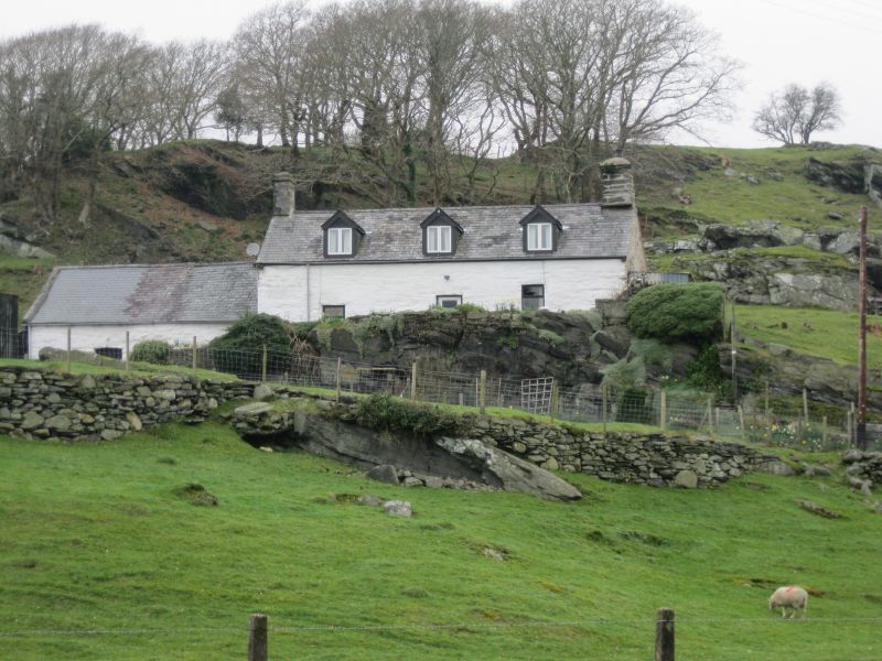
An C18 farmstead shown on the 1842 Tithe map.
A 1½-storey farm house of whitened rubble stone, slate roof and stone end stacks, larger and original to the R and later to the L. The central entrance has a replacement half-glazed boarded door. It is flanked by replacement windows in earlier openings, of which the R hand is at a higher level due to the sloping site. Three late C19 gabled dormers have replacement 2-light casement windows and slate-hung sides.
Set back to the L is a lower outbuilding, probably a cow house originally, of whitened stone and slate roof. It has 2 replacement boarded doors, at higher level on the R side.
Not inspected.
Listed for its special architectural interest as a well-preserved linear farmstead retaining good vernacular character.
External links are from the relevant listing authority and, where applicable, Wikidata. Wikidata IDs may be related buildings as well as this specific building. If you want to add or update a link, you will need to do so by editing the Wikidata entry.


Other nearby listed buildings
