Approximate Location Map
Large Map »
Latitude: 52.939 / 52°56'20"N
Longitude: -4.1429 / 4°8'34"W
OS Eastings: 256091
OS Northings: 340108
OS Grid: SH560401
Mapcode National: GBR 5P.LVGT
Mapcode Global: WH55L.BDG7
Plus Code: 9C4QWVQ4+JV
Entry Name: The Old Granary
Listing Date: 1 April 1974
Last Amended: 26 September 2005
Grade: II
Source: Cadw
Source ID: 4444
Building Class: Agriculture and Subsistence
ID on this website: 300004444
Location: Set back on the S side of Dublin Street approximately 100m SW of the Market Square.
County: Gwynedd
Community: Porthmadog
Community: Porthmadog
Locality: Tremadog
Traditional County: Caernarfonshire
Tagged with: Granary
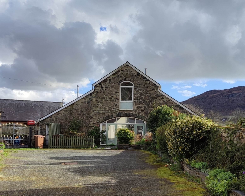
Tremadog was a town created by William Madocks (1773-1828) in the first decade of the C19 on reclaimed land known as Traeth Mawr, the estuary of Afon Glaslyn. It was originally intended to be a post town on a direct road between London and Dublin, via Porthdinllaen on the Lleyn peninsula, a project that in due course lost out to the Holyhead Road. Tremadog was laid out around a market square, with market hall, coaching inn, houses and shops, with a church and chapel just outside the centre. Building of this small planned development, as well as a separate woollen manufactory, began c1805 and was largely completed by the time Richard Colt Hoare described it in 1810. The Old Granary, built as a granary and coach house, was part of this first phase of development and is shown on the 1842 Tithe map. It was later a carpenter's shop and was converted into 2 dwellings in the 1970s.
An aisled former coach house and granary of coursed rubble stone and slate roof. In the gable-end N front is a wide segmental arch with freestone voussoirs, now infilled with glazing. Above it is a segmental-headed former doorway converted to a window, with pulley block above it. In the lean-to aisles is a doorway to the L blocked and converted to a small window, and a replacement glazed door to the R. The L (E) side wall has openings introduced when it was converted for domestic use: a recessed door with window to its L, a low raked roof dormer to the aisle, skylights to the main range, and 2-window extension to the L end. Likewise the R (W) side wall has modern openings: 2 small windows in deeper, partly blocked earlier openings, and 2 skylights. The 2-window rear (S) gable end has replacement windows under original timber lintels and a loft pitching eye.
Modernised interior.
Listed, notwithstanding alteration, for its special historical interest as an integral component of the original planned town, where it fulfilled an important economic role. The building retains some distinctive character giving evidence of its original use, and contributes to the historical integrity of the town.
External links are from the relevant listing authority and, where applicable, Wikidata. Wikidata IDs may be related buildings as well as this specific building. If you want to add or update a link, you will need to do so by editing the Wikidata entry.


Other nearby listed buildings
