History in Structure

Ivy Bridge (partly in Talsarnau community)

A Grade II Listed Building in Maentwrog, Gwynedd

More Photos »
Approximate Location Map
Large Map »

Coordinates

Latitude: 52.9353 / 52°56'7"N

Longitude: -4.0037 / 4°0'13"W

OS Eastings: 265430

OS Northings: 339423

OS Grid: SH654394

Mapcode National: GBR 5V.M5X2

Mapcode Global: WH55N.GHP2

Plus Code: 9C4QWXPW+4G

Entry Name: Ivy Bridge (partly in Talsarnau community)

Listing Date: 30 November 1966

Last Amended: 25 February 2005

Grade: II

Source: Cadw

Source ID: 4793

Building Class: Transport

Also known as: Ivy Bridge (that part in Talsarnau Community)

ID on this website: 300004793

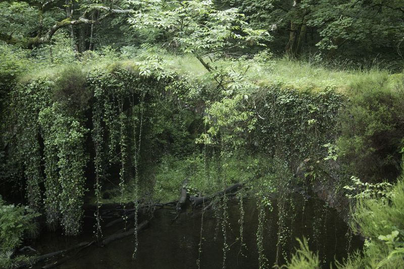
Location: Spanning the Afon Prysor, c. 1.5km to S and W of Maentwrog and 150m SE of Pont Felinrhyd-fawr. Spans the boundary between Maentwrog and Talsarnau.

County: Gwynedd

Community: Maentwrog

Community: Maentwrog

Traditional County: Merionethshire

Tagged with: Bridge Road bridge

Find accommodation in
Maentwrog

History

C18 or earlier bridge that carried the original packhorse route between Harlech and Maentwrog.

Exterior

Narrow bridge of roughly coursed rubble masonry. A wide segmental arch of rough stone voussoirs; no parapet.

Reasons for Listing

Listed as an unusual survivor of an early packhorse bridge, notable for the length of its span, and the narrowness of its width.

External Links

External links are from the relevant listing authority and, where applicable, Wikidata. Wikidata IDs may be related buildings as well as this specific building. If you want to add or update a link, you will need to do so by editing the Wikidata entry.

Recommended Books

Other nearby listed buildings

  • II Ivy Bridge (that part in Talsarnau Community)
    Spanning the Afon Prysor, c1.5km to S and W of Maentwrog and 150m SE of Pont Felinrhyd Fawr. Spans the boundary between Maentwrog and Talsarnau communities.
  • II Pont Felinrhyd-fawr (that part in Talsarnau Community)
    Carrying the A496, c1.5km to S and W of Maentwrog and spanning the Afon Prysor. Spans the boundary between Maentwrog and Talsarnau communities.
  • II Pont Felinrhyd-fawr (partly in Talsarnau community)
    Carrying the A496, c 1.5km to S and W of Maentwrog and spanning the Afon Prysor. Spans the boundary between Maentwrog and Talsarnau.
  • II Haybarn (E) at Felinrhyd-fawr
    Set at right angles to the S side of the A496 to E of the farmhouse and adjacent buildings at Felinrhyd-fawr farm; parallel to an adjacent haybarn to W.
  • II Haybarn (W) at Felinrhyd-fawr
    Set at right angles to the S side of the A496 to E of the farmhouse and adjacent buildings at Felinrhyd-fawr farm; parallel to an adjacent haybarn to E.
  • II Milepost
    Set along the NE side of the A496 between Pont Felinrhyd-fawr and Maentwrog; c.300m NE of Pont Felinrhyd-fawr.
  • II Forge and open storage area at Felinrhyd-fawr
    Located at the S side of the A496 c2km SW of Maentwrog. The forge and open storage area are to the rear of the house at Felinrhyd-fawr, with narrow stone flagged yard between. Hillside rises steeply
  • II Felinrhyd-fawr
    Located at the S side of the A496 c2km SW of Maentwrog.

BritishListedBuildings.co.uk is an independent online resource and is not associated with any government department. All government data published here is used under licence. Please do not contact BritishListedBuildings.co.uk for any queries related to any individual listed building, planning permission related to listed buildings or the listing process itself.

British Listed Buildings is a Good Stuff website.