History in Structure

Cartref

A Grade II Listed Building in Maentwrog, Gwynedd

More Photos »
Approximate Location Map
Large Map »

Coordinates

Latitude: 52.9451 / 52°56'42"N

Longitude: -3.9887 / 3°59'19"W

OS Eastings: 266471

OS Northings: 340480

OS Grid: SH664404

Mapcode National: GBR 5W.LHL6

Mapcode Global: WH55N.P7VL

Plus Code: 9C4RW2W6+2G

Entry Name: Cartref

Listing Date: 30 November 1966

Last Amended: 25 February 2005

Grade: II

Source: Cadw

Source ID: 4831

Building Class: Domestic

ID on this website: 300004831

Location: Set alongside the W side of Bull Street (A496) in the village of Maentwrog; located to SE of Church of St. Twrog at the rear of Llys Twrog.

County: Gwynedd

Community: Maentwrog

Community: Maentwrog

Traditional County: Merionethshire

Tagged with: Cottage

Find accommodation in
Maentwrog

History

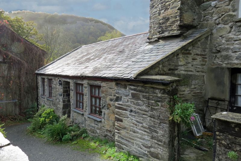
Probably mid C19 house. The building is not marked on the tithe map of the parish, 1840, but was built on a parcel of land described as 'Tir y Llan'; owned by Louisa Jane Oakeley of Plas Tan-y-bwlch and occupied by Cadwaladr Evans.
Offered up for sale in the auction of the Plas Tan-y-bwlch estate, 1910, in Lot 12 'The Picturesque Rural Village of Maentwrog'. The property was described as Tanffordd - Cottage and buildings, occupied by Griffith Roberts, for an annual rent of £8-0s-0d (£8.00).

Exterior

A small single storey cottage. Built of mortared rubble masonry. Slate roof with stone coping at S end and large stone stack at N gable. The principal elevation faces the road to E, a 4-window range with central doorway; windows are modern timber casements.

Interior

The interior was not inspected at the time of the survey (June/July 2003).

Reasons for Listing

Listed, notwithstanding some alterations, as a small early to mid C19 house retaining traditional character that forms a group with the other buildings at the centre of the estate village of Maentwrog.

External Links

External links are from the relevant listing authority and, where applicable, Wikidata. Wikidata IDs may be related buildings as well as this specific building. If you want to add or update a link, you will need to do so by editing the Wikidata entry.

Recommended Books

Other nearby listed buildings

  • II Llys Twrog
    Set at right angles to the W side of Bull Street (A496) in the centre of the village of Maentwrog; to SE of the Church of St. Twrog.
  • II Steps up to Penlan, with flanking walls
    On the E side of Bull Street in the village of Maentwrog S of the War Memorial
  • II Bron-y-wern
    Set back slightly from the W side of Bull Street (A496) in the centre of the village of Maentwrog; to S of Pen-y-Bryn and the lychgate to the Church of St. Twrog.
  • II Pen-y-Bryn
    Set alongside the W side of Bull Street (A496) in the centre of the village of Maentwrog; directly ESE of the Church of St. Twrog.
  • II Bryn or Penlan flats
    In an elevated position, set back from the E side of Bull Street in the village of Maentwrog; to ESE of the Church of St. Twrog. Bryn is located to S of Penlan.
  • II Lychgate to Church of St. Twrog
    Set along the W side of Bull Street (A496) in the centre of the village of Maentwrog; located between Neuadd Llewelyn and Pen-y-Bryn.
  • II Argraig
    In an elevated position, set back from the E side of Bull Street in the village of Maentwrog; to ESE of the Church of St. Twrog. Arcraig is set to the rear of, and between Penlan and Bryn.
  • II Neuadd Llewelyn
    Set along the W side of Bull Street (A496) at the N end of the village of Maentwrog; at the end of the row of houses in alignment with The Grapes Hotel, to S of Glan Dwyryd.

BritishListedBuildings.co.uk is an independent online resource and is not associated with any government department. All government data published here is used under licence. Please do not contact BritishListedBuildings.co.uk for any queries related to any individual listed building, planning permission related to listed buildings or the listing process itself.

British Listed Buildings is a Good Stuff website.