Approximate Location Map
Large Map »
Latitude: 52.7445 / 52°44'40"N
Longitude: -3.8849 / 3°53'5"W
OS Eastings: 272854
OS Northings: 317986
OS Grid: SH728179
Mapcode National: GBR 91.00ED
Mapcode Global: WH56P.988V
Plus Code: 9C4RP4V8+R2
Entry Name: Y Bont Fawr
Listing Date: 19 June 1990
Last Amended: 19 June 1990
Grade: II
Source: Cadw
Source ID: 4927
Building Class: Transport
ID on this website: 300004927
Location: Spanning the River Wnion and linking the town with the A470.
County: Gwynedd
Community: Dolgellau
Community: Dolgellau
Built-Up Area: Dolgellau
Traditional County: Merionethshire
Tagged with: Bridge
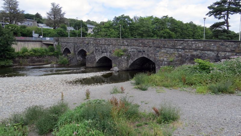
A substantial road bridge dating in part from l638. Rebuilt above the spandrels in the early C19. It was largely remodelled in 1870, widened on the upstream side with two new arches at the N end and inclined to take the road over the Cambrian Railway line from Penmaenpool. A modern concrete span now crosses the A470 and a modern footbridge obscures the upstream side.
Twin carriageway stone bridge inclined from N to S. 7 arches, southern five C17 up to spandrels, stone voussoirs, buttresses. Later Cl9 work to northern two arches and upstream side, recessed arch rings, stone voussoirs, rock faced masonry. Prowed cutwaters, 2 modern on upstream side. Late Cl9 parapet, string course, capstones re-used from earlier work. Plain pilasters rise from buttresses on downstream side.
Group value with buildings at N end of Bridge Street.
External links are from the relevant listing authority and, where applicable, Wikidata. Wikidata IDs may be related buildings as well as this specific building. If you want to add or update a link, you will need to do so by editing the Wikidata entry.


Other nearby listed buildings
