History in Structure

The Cross Foxes Inn

A Grade II Listed Building in Dolgellau, Gwynedd

More Photos »
Approximate Location Map
Large Map »

Coordinates

Latitude: 52.7338 / 52°44'1"N

Longitude: -3.8282 / 3°49'41"W

OS Eastings: 276656

OS Northings: 316693

OS Grid: SH766166

Mapcode National: GBR 93.0VGK

Mapcode Global: WH67V.5KB2

Plus Code: 9C4RP5MC+GP

Entry Name: The Cross Foxes Inn

Listing Date: 19 June 1990

Last Amended: 19 June 1990

Grade: II

Source: Cadw

Source ID: 5122

Building Class: Commercial

Also known as: Cross Foxes Inn
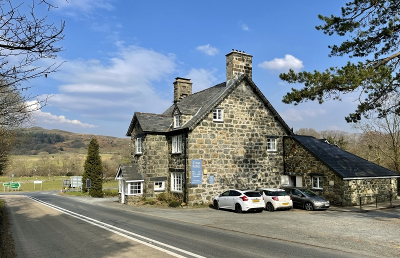
Cross Foxes Inn, Dolgellau

ID on this website: 300005122

Location: Prominently situated in open country at the Junction of the A487 to Machynlleth with the A470.

County: Gwynedd

Community: Dolgellau

Community: Dolgellau

Traditional County: Merionethshire

Tagged with: Pub Inn

Find accommodation in
Dolgellau

History

Dated l859.

Exterior

2 storey, 3 window Inn with storeyed porch. Coursed, squared rubble masonry, steeply pitched slate roof, oversailing eaves; deep verges, exposed purlins, slated bargeboards. Stone stacks, rendered to right, slate water tabling.
Two gabled stone dormers, bargeboards, pendants. Modern window to left, two light casement to right. 2 light, small paned, casement windows to lst floor, deep slate lintels. Lozenge shaped slate tablet to apex of storeyed porch, inscribed RR 1859. Tripartite small paned casement windows to ground floor. 4 pane fixed light windows to sides of storeyed porch.
Later, timber outer porch on stone base, small paned glazing. Black-and-white gablet, bargeboards.
Low outhouse adjoins to left. Rubble masonry, slate roof with swept eaves. Lateral stone stack to front. Raking dormer over doorway.

Modern extension parallel to rear.

External Links

External links are from the relevant listing authority and, where applicable, Wikidata. Wikidata IDs may be related buildings as well as this specific building. If you want to add or update a link, you will need to do so by editing the Wikidata entry.

Recommended Books

Other nearby listed buildings

  • II Pont Gwanas
    On the loop of old road cut off by the new bridge to the North of the Cross Foxes Inn.
  • II Pont Gwanas (partly in Dolgellau Community)
    Spanning the Afon Clywedog immediately N of the new road bridge on the course of the former road.
  • II Gwanas Farmhouse including attached Byre Range
    Located off the A 470 about 4 km S of Brithdir; accessed via a farm track leading W from the Caerynwch lane.
  • II Barn at Gwanas Fawr
    Immediately to the E of Gwanas Fawr, facing the house.
  • II Gwana Fawr
    Located on a rise some 4.2km S of Brithdir to the S of the A470; accessed via an unmetalled track.
  • II Tyddyn Llwyn Farmhouse
    Located 3.5 Km S of Brithdir, to the E of a lane running S from the B4416 to the A 470; accessed via a gated farm track.
  • II Caerynwch
    Located in its own park 2km SE of Brithdir in a hollow facing the Afon Clywedog; at the end of a long drive running S from the Pont ar Ddibin.
  • II* Plas Hen
    Located some 2km SW of Brithdir immediately to the E of a narrow lane linking the B 4416 with the A 470; raised above the lane and built into the bank of a hill. Also called 'Old Caerynwch'.

BritishListedBuildings.co.uk is an independent online resource and is not associated with any government department. All government data published here is used under licence. Please do not contact BritishListedBuildings.co.uk for any queries related to any individual listed building, planning permission related to listed buildings or the listing process itself.

British Listed Buildings is a Good Stuff website.