Approximate Location Map
Large Map »
Latitude: 53.2553 / 53°15'19"N
Longitude: -4.4227 / 4°25'21"W
OS Eastings: 238480
OS Northings: 375882
OS Grid: SH384758
Mapcode National: GBR HNG3.0WV
Mapcode Global: WH42S.1F7R
Plus Code: 9C5Q7H4G+4W
Entry Name: Melin Gwalchmai
Listing Date: 5 April 1971
Last Amended: 23 September 1998
Grade: II
Source: Cadw
Source ID: 5333
Building Class: Industrial
ID on this website: 300005333
Location: Set back from the SE side of a country road SW of Gwalchmai and c. 600m SW of the church of St. Morhaiarn.
County: Isle of Anglesey
Community: Trewalchmai
Community: Trewalchmai
Locality: Gwalchmai
Built-Up Area: Gwalchmai
Tagged with: Windmill
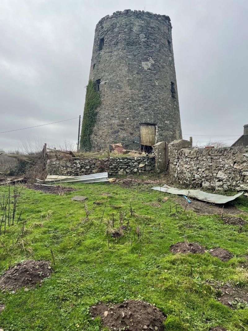
Probably built in the early C19, on land owned by the Treveilyr estate. The mill continued to be worked by wind power until as late as 1927. The cap and sails were removed shortly afterwards and the mill was then powered for several further years by a diesel engine housed in a shed next to the mill.
Anglesey was once the main grain-producing area of NW Wales, and the exposed nature of the landscape made it ideal for wind-powered corn mills (particularly when water supplies were unreliable). Construction of the mills flourished from early C18 to early C19. After the Corn Laws were repealed in 1846 the market was flooded by cheaper imported grain, which, combined with the availability of more convenient sources of power led to the demise of the windmill; by the end of the First World War only a handful were still operating. There are the visible remains of 31 windmill towers on the island, 6 of which have been converted to houses and only 18 remain as full towers; only 2 retain their original machinery and 1 has been restored to working order.
Full-height, 3-storey windmill tower; circular in plan with slightly tapering walls of rubble masonry, once rendered. Doorways at ground floor with segmental heads of rough voussoirs, rectangular windows at stages above. Mill now capped with concealed flat roof. A narrow tunnel leads from the E side of the mill to the adjoining former engine shed (of corrugated iron).
Listed as a substantially intact windmill tower, one of only 18 surviving on Anglesey. In early-mid C19 there were over 40 windmills operating on the island, grinding the large volumes of corn then being produced.
External links are from the relevant listing authority and, where applicable, Wikidata. Wikidata IDs may be related buildings as well as this specific building. If you want to add or update a link, you will need to do so by editing the Wikidata entry.


Other nearby listed buildings
