Approximate Location Map
Large Map »
Latitude: 53.3872 / 53°23'14"N
Longitude: -4.4938 / 4°29'37"W
OS Eastings: 234247
OS Northings: 390719
OS Grid: SH342907
Mapcode National: GBR HM8R.B99
Mapcode Global: WH424.Y483
Plus Code: 9C5Q9GP4+VF
Entry Name: Cefn Coch
Listing Date: 2 September 1952
Last Amended: 2 May 2001
Grade: II
Source: Cadw
Source ID: 5343
Building Class: Domestic
ID on this website: 300005343
Location: Set back from the E side of the A5025 between Llanfaethlu and Cemaes Bay; c2.3km SW of Tregele.
County: Isle of Anglesey
Town: Amlwch
Community: Mechell
Community: Mechell
Locality: Cefn Coch
Traditional County: Anglesey
Tagged with: House
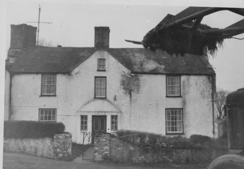
Probably C17 central hall type of house, modernised and added to in C19. The house was extensively modernised in the 1980s; the house was re-roofed, elevations were rendered and new doors and windows installed. David Lloyd, Rector of Llanfechell (b1691) is recorded as having bought Cefn Coch from Richard Roberts of Rhosbadric, Aberffraw, he was married to Ellen, daughter of William Bulkeley of neighbouring Brynddu. Their daughter inherited the farm and married William, 3rd son of William Meyrick of Bodorgan. Cefn Coch then passed down through the Meyrick family to Thomas Meyrick (1718-1763), who is buried at the N end of the house; he was a renowned preacher and the house is thought to have been used for service in the mid C17. The farm is recorded as being owned by Edmund Edward Meyrick in the Tithe Schedule of Llanfechell, 1842, a holding of over 85 acres (34.43 hectares) farmed by Jane Hughes; finally sold out of the Meyrick family in the late C19.
C17 gentry farm-house comprising 3-window main range (2 storeyed with attics) and lower 2 storey single window range in line to the L (S), with gabled porch wing at the junction of the two. Render over stone, with slate roofs and exposed stone stacks at gable ends. Main range is broadly symmetrical with shallow central gable (surmounted by chimney stack) over entrance. This has doorway flanked by narrow windows. Window in outer bays, and the narrower window over the doorway, have been renewed in earlier openings. End-wall stacks are diagonally set with principal, larger stack to L hand gable. Lower range to the L (S) has enlarged or inserted window to R (N) and a small window alongside, and beneath eaves above (all detail modern). Two storeyed gabled porch advanced at the junction has an arched entrance to ground floor and small window above, again with modern detail. The rear elevation has scattered fenestration as well as rear doorway to main block; to the N end of the rear elevation, against the projecting stack, is a gravestone to Thomas Meyrick d1763, former owner of the house.
The main block has a central hallway, with principal rooms leading off to L and R, axial corridor to the rear leading to the S wing and mid C17 dog-leg staircase with turned balusters, moulded handrail and square newels with ball-finials. The stairs continue beyond a doorway, as plain oak stairs up to the former servants quarters in the attics; roof with pegged and collared hewn trusses. There is a hewn beam in the ground floor rooms which runs along the length of the house (now covered). The S block is thought, by the owners, to retain the original inglenook fireplace, now enclosed. Shallow panelled doors throughout.
Listed as a substantially C17 gentry house which, notwithstanding alteration to detail, retains strong elements of its original submedieval vernacular form and character.
External links are from the relevant listing authority and, where applicable, Wikidata. Wikidata IDs may be related buildings as well as this specific building. If you want to add or update a link, you will need to do so by editing the Wikidata entry.


Other nearby listed buildings
