Approximate Location Map
Large Map »
Latitude: 53.3055 / 53°18'19"N
Longitude: -4.209 / 4°12'32"W
OS Eastings: 252902
OS Northings: 381006
OS Grid: SH529810
Mapcode National: GBR HMZY.W67
Mapcode Global: WH53T.95YR
Plus Code: 9C5Q8Q4R+69
Entry Name: The Ship Inn
Listing Date: 12 May 1970
Last Amended: 27 August 2002
Grade: II
Source: Cadw
Source ID: 5377
Building Class: Commercial
Also known as: Ship Inn
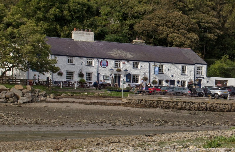
Ship Inn, Pentraeth
ID on this website: 300005377
Early C19 public house, the adjacent cottage later incorported into the inn and the range later modernised and extended by the addition of a single window range at the R end. In the Tithe Apportionment the Inn is referred to as Cei Newydd, owned by OJAF Meyrick of the Bodorgan Estate and tenanted by Richard Hughes. The Census Returns of the same year list the tenant at 'Quay' as William Jones, Publican; by 1851 the publican is recorded as Margaret Burton. The 'Cei' or quay was located to the front of the property along the coast of Red Wharf Bay which was a busy port and ship building area in the C19. It was also known as 'Cei Bach', and later 'Old Quay' before becoming known as 'The Ship Inn'.
C19 public house, a 2-storey, 7-window range with the single window range to R set back slightly from the main elevation. Built of rubble masonry, limewashed. Slate roof with rendered lateral stacks; one along the ridge to R of the doorway, a 2nd stack in the rear pitch to R of the roof. The ground floor openings have voussoir heads, the windows all have slate sills.
The Inn originally comprised the 4-window portion to the L of the range, the doorway offset to R under a shallow fanlight. Ground floor windows are 16-pane sashes, 1st floor has unequal 12-pane sashes (some now casements) set directly under the eaves. The 2-window portion to R (the former cottage) has 12-pane sash windows at a lower level to those of the original Inn and a centrally placed glazed door. At the far R is an added single window range with ground floor doorway under a 12-pane casement window; a similar window is set to the rear of the R gable return.
The interior has been modernised but retains a stone slab floor.
Listed as a good early C19 public house which retains a strong vernacular character and many original features such as the fenestration.
External links are from the relevant listing authority and, where applicable, Wikidata. Wikidata IDs may be related buildings as well as this specific building. If you want to add or update a link, you will need to do so by editing the Wikidata entry.


Other nearby listed buildings
