History in Structure

Bulkeley Monument

A Grade II Listed Building in Beaumaris, Isle of Anglesey

More Photos »
Approximate Location Map
Large Map »

Coordinates

Latitude: 53.2729 / 53°16'22"N

Longitude: -4.1142 / 4°6'50"W

OS Eastings: 259116

OS Northings: 377190

OS Grid: SH591771

Mapcode National: GBR JN61.Q5S

Mapcode Global: WH53V.SZ2S

Plus Code: 9C5Q7VFP+58

Entry Name: Bulkeley Monument

Listing Date: 23 September 1950

Last Amended: 13 July 2005

Grade: II

Source: Cadw

Source ID: 5700

Building Class: Commemorative

Also known as: Bulkeley Memorial

ID on this website: 300005700

Location: In a field on the summit of Twr Hill, on the NE side of a minor road between Beaumaris and Llanddona, approximately 1.8km NW of Beaumaris.

County: Isle of Anglesey

Community: Beaumaris (Biwmares)

Community: Beaumaris

Locality: Twr Hill

Traditional County: Anglesey

Tagged with: Obelisk Monument

Find accommodation in
Bangor

History

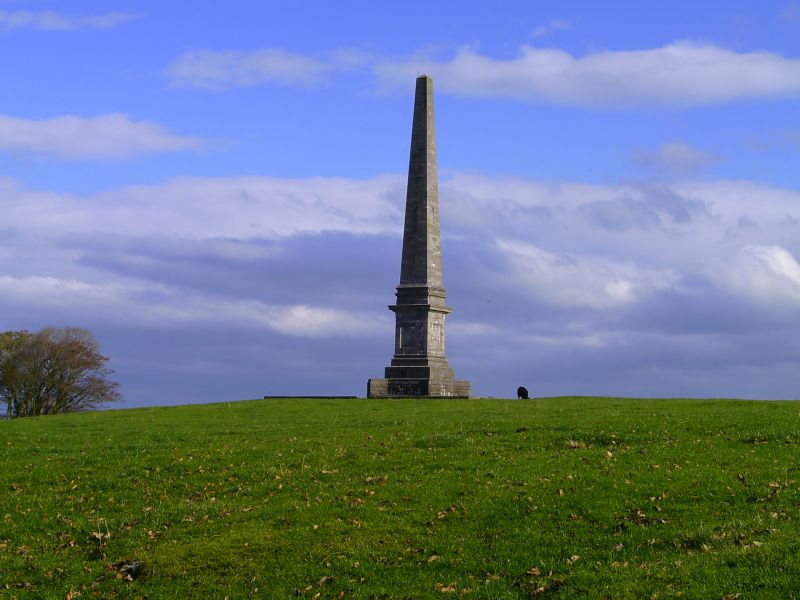
Built to commemorate Sir Richard Bulkeley Williams Bulkeley (1801-75), and shown on the 1889 Ordnance Survey. Sir Richard inherited Baron Hill in 1822 from his uncle, the 7th Viscount Bulkeley. He remodelled the house and grounds and, as the dominant landowner in Beaumaris, he initiated much of the town's C19 development as a resort.

Exterior

A tall ashlar obelisk on a broad levelled platform, and a coursed rock-faced plinth with diagonal buttresses. The base is panelled, with inscription on the S side, under a moulded cornice.

Reasons for Listing

Listed for its special interest as a fine and prominent memorial to a member of the most important gentry family in Beaumaris and a leading figure in the C19 development of Beaumaris town.

External Links

External links are from the relevant listing authority and, where applicable, Wikidata. Wikidata IDs may be related buildings as well as this specific building. If you want to add or update a link, you will need to do so by editing the Wikidata entry.

Recommended Books

Other nearby listed buildings

  • II Barn at Twr Hill
    Set back behind modern farm buildings on the SW side of a moinor road between Beaumaris and Llanddona, approximately 2km NW of Beaumaris town centre.
  • II Bryn Bela
    On the SW side of a minor road between Beaumaris and Llanddona, approximately 2.2km NW of Beaumaris town centre.
  • II Boundary stone N of Bryn Bela
    Set into the wall on the N side of Bryn Bela, facing the road.
  • II Elusendai
    Set slightly back from the road approximately 1.8km W of Beaumaris.
  • II Turret Lodge (pair of lodges)
    On the NE side of a road junction of the B5109 and a minor road to Llanddona, approximately 1.5km W of Beaumaris.
  • II* Baron Hill
    In extensive grounds although now obscured by woodland, in a prominent position overlooking Beaumaris Castle, approximately 0.9km NW of Beaumaris town centre, on the N side of the B5109.
  • II Viewing platform and colonnade on the S side of Baron Hill
    On the S side of the house, immediately N of the bridge over the B5109.
  • II Bridge over B5109 on drive to Baron Hill
    Approximately 300m SSW of Baron Hill and 1km WNW of Beaumaris town centre.

BritishListedBuildings.co.uk is an independent online resource and is not associated with any government department. All government data published here is used under licence. Please do not contact BritishListedBuildings.co.uk for any queries related to any individual listed building, planning permission related to listed buildings or the listing process itself.

British Listed Buildings is a Good Stuff website.