Approximate Location Map
Large Map »
Latitude: 51.6843 / 51°41'3"N
Longitude: -5.088 / 5°5'16"W
OS Eastings: 186631
OS Northings: 202905
OS Grid: SM866029
Mapcode National: GBR G4.ZXH4
Mapcode Global: VH1RX.RXJQ
Plus Code: 9C3PMWM6+PQ
Entry Name: Church of St Mary
Listing Date: 14 May 1970
Last Amended: 26 January 1996
Grade: II
Source: Cadw
Source ID: 5921
Building Class: Religious, Ritual and Funerary
ID on this website: 300005921
County: Pembrokeshire
Community: Angle
Community: Angle
Traditional County: Pembrokeshire
Tagged with: Church building
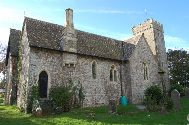
Mediaeval W tower. Most of the original church was demolished in the early C19. The present nave, chancel, transept, vestry and porch are by R K Penson, 1853. Part of N wall of nave is mediaeval.
The tower has a pointed vault at 1st floor level which opens into the nave. Domed and tiled tower roof with corbelled and crenellated parapet. Stairs turret at SW corner with a slight projection at each face. The entrance to the stairs from within the tower is about 1.4 m below the present floor level. The W window in the tower at ground storey is of late mediaeval type with an irregular hood mould and cinquefoil light heads, much restored. There is a blocked W door opening beneath. Belfry openings with stone louvres.
The church was rebuilt in Early English and Decorated styles. The external masonry is generally in uncoursed ashlar, but the N elevation is in a rougher technique to blend with the retained mediaeval masonry in part of N nave wall. Red tile roof, some recently relaid.
Mirehouse family memorials are in the nave. Some older memorials of other families were found in fragments, repaired and installed in the N transept after the rebuilding. Font of Norman cushion type, scraped.
Listed for mediaeval tower.
External links are from the relevant listing authority and, where applicable, Wikidata. Wikidata IDs may be related buildings as well as this specific building. If you want to add or update a link, you will need to do so by editing the Wikidata entry.


Other nearby listed buildings
