History in Structure

Milestone

A Grade II Listed Building in Narberth, Pembrokeshire

More Photos »
Approximate Location Map
Large Map »

Coordinates

Latitude: 51.7977 / 51°47'51"N

Longitude: -4.7285 / 4°43'42"W

OS Eastings: 211953

OS Northings: 214528

OS Grid: SN119145

Mapcode National: GBR CW.XZS4

Mapcode Global: VH2P6.023Q

Plus Code: 9C3QQ7XC+3J

Entry Name: Milestone

Listing Date: 17 May 1988

Last Amended: 17 May 1988

Grade: II

Source: Cadw

Source ID: 6536

Building Class: Transport

ID on this website: 300006536

Location: In the verge set up against the hedge bank some 70 yds SE of the junction with Kiln Park Road.

County: Pembrokeshire

Community: Narberth (Arberth)

Community: Narberth

Locality: Greenway

Built-Up Area: Narberth

Traditional County: Pembrokeshire

Tagged with: Milestone

Find accommodation in
Narberth

Exterior

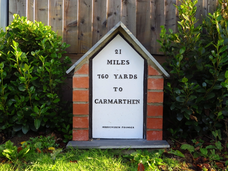
Early C19 milestone. Gabled cast iron plaque, white painted. Raised lettering, reading "21 MILES 160 YARDS TO CARMARTHEN".

External Links

External links are from the relevant listing authority and, where applicable, Wikidata. Wikidata IDs may be related buildings as well as this specific building. If you want to add or update a link, you will need to do so by editing the Wikidata entry.

Recommended Books

Other nearby listed buildings

  • II Parish Boundary Stone
    Set on the roadside up against the right hand gatepier of a fieldgate opposite the entrance to Blackaldern.
  • II Coach House at Blackaldern
    Situated beyond the house at the end of a long drive leading from the B4314 some 300 yds SE of the junction with Kiln Park Road.
  • II Stable adjoining Greenway Farm
    Gable end on to the road 300 yds NW from the junction with Kiln Park Road.
  • II Blackaldern
    Situated at the end of a long drive leading from the B4314 some 300 yds SE of the junction with Kiln Park Road.
  • II Cartshed adjoining Greenway Farm
    Gable end on to the road 300 yds NW from the junction with Kiln Park Road.
  • II Greenway Farm
    Gable end to the roadside 300 yds NW from the junction with Kiln Park Road.
  • II Outhouse at Greenway Farm
    In the farmyard opposite the farmhouse 300 yds NW of the junction with Kiln Park Road.
  • II Byre at Greenway Farm
    In the farmyard opposite the farmhouse 300 yds NW of the junction with Kiln Park Road.

BritishListedBuildings.co.uk is an independent online resource and is not associated with any government department. All government data published here is used under licence. Please do not contact BritishListedBuildings.co.uk for any queries related to any individual listed building, planning permission related to listed buildings or the listing process itself.

British Listed Buildings is a Good Stuff website.