Approximate Location Map
Large Map »
Latitude: 51.7377 / 51°44'15"N
Longitude: -4.6974 / 4°41'50"W
OS Eastings: 213846
OS Northings: 207781
OS Grid: SN138077
Mapcode National: GBR GF.3QY0
Mapcode Global: VH2PD.JLJ6
Plus Code: 9C3QP8Q3+32
Entry Name: Kilgetty Colliery Chimney Base
Listing Date: 31 July 1991
Last Amended: 1 September 1997
Grade: II
Source: Cadw
Source ID: 6557
Building Class: Industrial
ID on this website: 300006557
Location: In the yard of Stepaside Coachworks off Kilgetty Lane, behind the Weighbridge Office and to the N of the winding engine house of Engine Pit.
County: Pembrokeshire
Town: Tenby
Community: Amroth
Community: Amroth
Locality: Stepaside
Built-Up Area: Stepaside
Traditional County: Pembrokeshire
Tagged with: Architectural structure
Kilgetty Colliery consisted of several pits, the first documented of which was sunk in 1775. These were abandoned and re-opened on numerous occasions. A beam engine was bought from the Neath Abbey Iron Company for the colliery in c.1811, and further pits were sunk in the 1840s. During the 1850s the colliery prospered, providing coal for the Kilgetty (or Stepaside) Ironworks, but it declined in the 1860s. It last operated from 1937 to 1939 under the Kilgetty Anthracite Colliery Company, when over 250 men were employed.
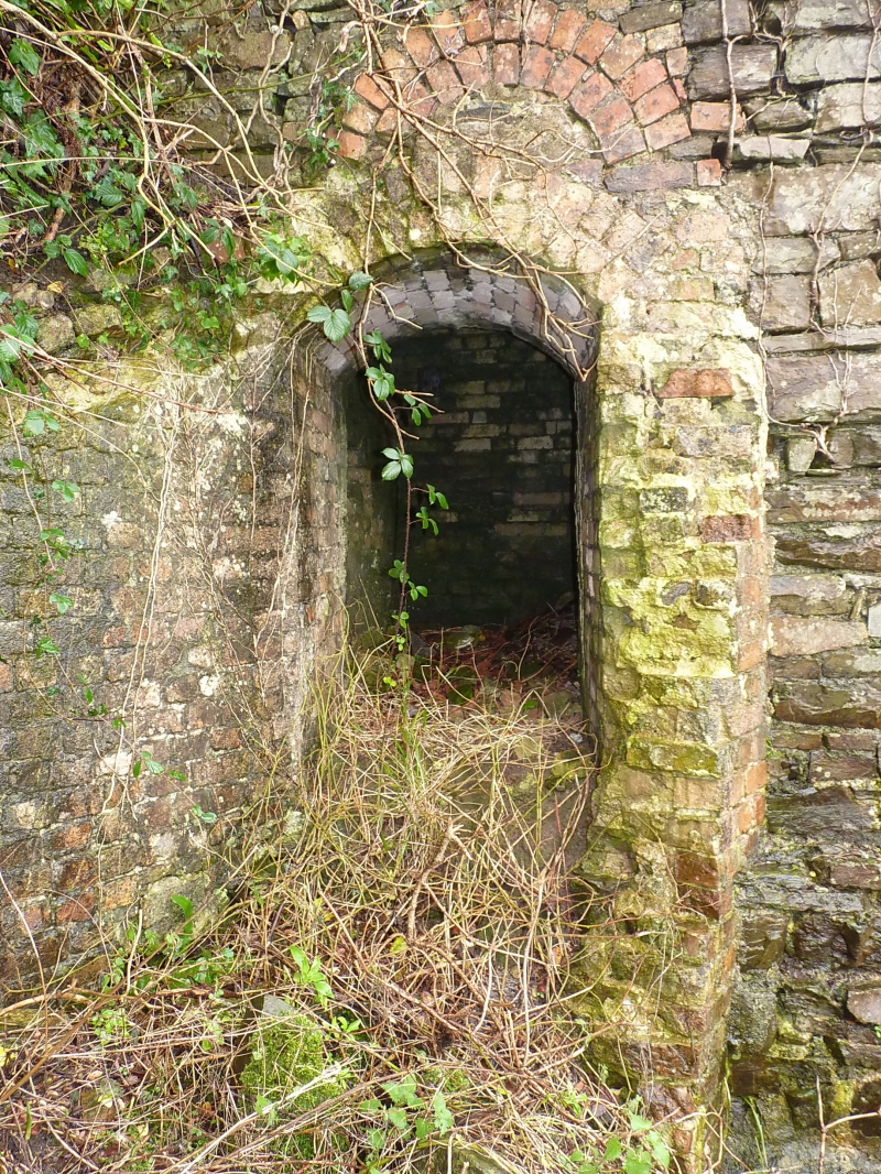
The chimney probably dates from the early to mid C19. The height appears to have been about 20 m but the upper part was demolished by the Army in 1972. It appears to have been built as a boilerhouse chimney, but may later have served for mine ventilation: such ventilation chimneys are a rarity.
The stump of the chimney is about 2.5 m square externally and 1.25 m square internally, and rises to a surviving height of about 4.5 m above the ground level of the yard. It is built of rubble sandstone with dressed quoins in a style similar to that of the weighbridge office. The chimney tapers slightly to a height of about 3 m, above which its taper is more gentle. The uppermost surviving parts are roughly broken and covered in ivy. Two arched openings into the base are visible. The opening in the N side is connected to a flue in firebrick which can be traced for several metres along the bank at the E side of the yard, but the nearside wall and the arched top of the flue have disappeared. The flue is about 1 m in height internally above present ground level. This may have been the site of a boiler house. A second aperture in the chimney faces W, above the height at which the main flue joins. This aperture 0.6 m wide by 0.8 m high has a hinged iron access cover and was for servicing the chimney.
The chimney is included for group value with the surviving engine house and weighbridge house.
Listed for group value with the surviving engine house and weighbridge house.
External links are from the relevant listing authority and, where applicable, Wikidata. Wikidata IDs may be related buildings as well as this specific building. If you want to add or update a link, you will need to do so by editing the Wikidata entry.


Other nearby listed buildings
