Approximate Location Map
Large Map »
Latitude: 51.8534 / 51°51'12"N
Longitude: -3.1474 / 3°8'50"W
OS Eastings: 321069
OS Northings: 217828
OS Grid: SO210178
Mapcode National: GBR F0.TFXP
Mapcode Global: VH6CH.DPG0
Plus Code: 9C3RVV33+92
Entry Name: Village Farm
Listing Date: 19 July 1963
Last Amended: 21 October 1998
Grade: II
Source: Cadw
Source ID: 6678
Building Class: Domestic
ID on this website: 300006678
Location: Located in Llangattock village, immediately S of the Church. Bounded by a stone wall to the front with cast iron gate.
County: Powys
Community: Llangattock (Llangatwg)
Community: Llangattock
Built-Up Area: Llangattock
Traditional County: Brecknockshire
Tagged with: Building
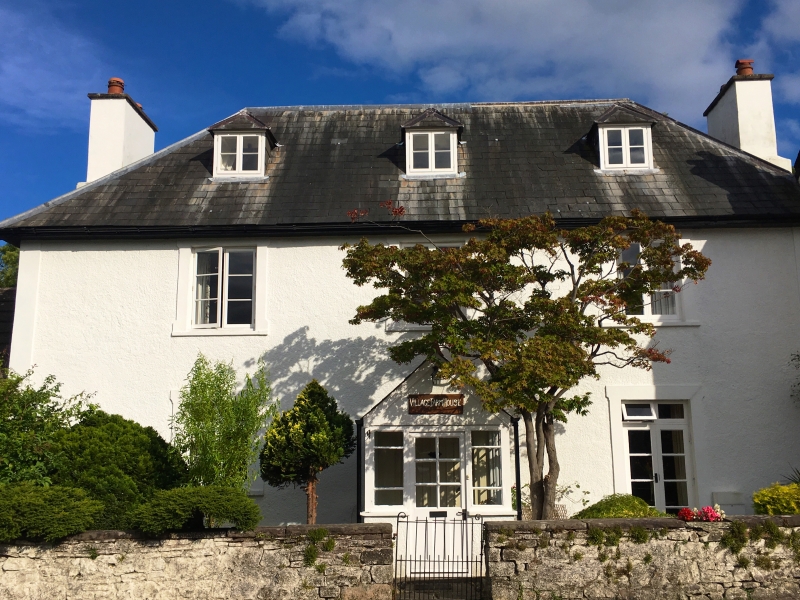
Late C17 to early C18. Photographs show that windows at the front of the house were replaced after the 1960s. Previously, the porch was flanked by sashes with multi-pane casements above. The barn to the L of the house had a half-hipped roof, with a planked door and casement window to the front.
Symmetrical plan 3-window house of 2 storeys, an attic and cellar. Hipped slate roof, 2 large end stacks, and full-height staircase projection to rear. The house is rough cast with angle pilaster strips and eared architraves. C20 half-glazed, gabled porch leading to a wide panelled and ribbed front door The entrance is flanked by a 2-light casement window to the L and French Doors to the R in similar style. The 1st floor has 3 similar windows, and the attic 3 hipped roof dormers with 2-light casement windows.
The S gable end abutts the adjacent house. The rear has a full height stair projection with hipped slate roof, and 2-light casement stairlights with quarries to the 1st and attic storeys. The rear door is inside a single-storey lean-to with hipped tiled roof and side door. It abutts a much larger 2-storey lean-to which extends to the SE angle of the house, constructed from rubble masonry under a single-pitch slate roof, and the ground floor window is under a stone dripmould. (The windows of both lean-tos are C20 and in different styles.) To the R of the stair projection is a pair of metal-framed French Doors, which replaced a window similar to those in the stair projection. A former barn adjoins to the N, now converted to garages and holiday accommodation with attic dormers.
Three-unit interior with central stair-hall flanked by reception rooms. The kitchen is in the rear lean-to. Dog-leg staircase opposite front entrance, with substantial square section handrails, large square newel posts with orb finials and pendants, and turned balusters. To the side of the staircase is the entrance to the kitchen and a door to the cellar, which has a flagstone floor. Towards the top of the cellar stairs is a former window opening containing 6 turned mullions which match the main staircase balusters. The room to the S has chamfered cross beams and a massive stone fireplace with chamfered stone lintel and splayed, chamfered sides. There is a wooden lintel above, and a wide stone hearth in front of the fireplace. The N unit has a C20 fireplace but older woodwork can be seen behind. The front door has long decorative strap hinges on its internal side. The stairlight between the ground and 1st floors has a chamfered timber mullion, while the square quarries contain early glass. Off the landing to the S is a half lit door within a fluted frame under a round arch. The rooms on the 1st floor are entered through planked doors and have exposed ceiling beams without chamfers. The attic stairlight has a plain central mullion, but has quarries as on the level below. Steeply pitched roof with coupled rafters.
Listed as a house of c 1700 origin retaining its plan form and with well preserved internal features.
External links are from the relevant listing authority and, where applicable, Wikidata. Wikidata IDs may be related buildings as well as this specific building. If you want to add or update a link, you will need to do so by editing the Wikidata entry.


Other nearby listed buildings
