History in Structure

Former Cartshed and Byre at Pen-y-Cefn Farm

A Grade II Listed Building in Cilcain, Flintshire

More Photos »
Approximate Location Map
Large Map »

Coordinates

Latitude: 53.1915 / 53°11'29"N

Longitude: -3.2156 / 3°12'56"W

OS Eastings: 318876

OS Northings: 366738

OS Grid: SJ188667

Mapcode National: GBR 6W.2Z9Z

Mapcode Global: WH774.K1YM

Plus Code: 9C5R5QRM+JP

Entry Name: Former Cartshed and Byre at Pen-y-Cefn Farm

Listing Date: 16 October 1995

Last Amended: 16 October 1995

Grade: II

Source: Cadw

Source ID: 7575

Building Class: Agriculture and Subsistence

ID on this website: 300007575

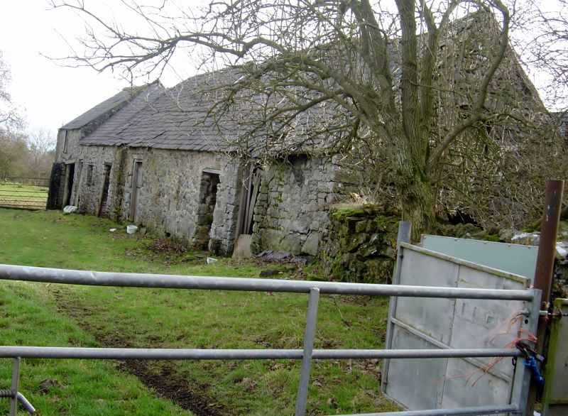
Location: Situated opposite the house at Pen-y-cefn, set at right-angles to the road.

County: Flintshire

Community: Cilcain

Community: Cilcain

Locality: Cefn

Traditional County: Flintshire

Tagged with: Carriage house

Find accommodation in
Halkyn

History

Perhaps C17 or earlier C18, the barn probably originated as a cartshed and byre, the arched cartshed opening was later blocked and a smaller door inserted. Two successive additions were made to the left, probably in the C19.

Exterior

Rubble with roughly squared quoins, slate roof. To the right is a blocked arched entrance with a door set in it. To the left of this a series of 3 doors, the central one taller than the others. A vertical joint separates this from a cartshed with loft over and a higher roofline. Doors are generally plank doors with strap hinges.

Interior

Not accessible at time of 1995 survey.

Reasons for Listing

Listed for group value with Pen-y-cefn farmhouse.

External Links

External links are from the relevant listing authority and, where applicable, Wikidata. Wikidata IDs may be related buildings as well as this specific building. If you want to add or update a link, you will need to do so by editing the Wikidata entry.

Recommended Books

Other nearby listed buildings

  • II Pen-y-Cefn
    Situated 2km NE of Cilcain, reached by a series of by-roads running S off the A541.
  • II Coed Du Hospital
    Situated in landscaped grounds above the River Alyn 1.2 km W of Rhydymwyn, reached from a by road running W off the A541.
  • II Plas Wilkin (Including attached farmyard ranges)
    Situated 1.2 km W of Rhydymwyn, reached from a by road running W off the A541 at Rhydymwyn.
  • II Bath House
    Situated 0.2km W of Coed Du immediately to the W of the road from Rhydymwyn to Coed Du and Plas Wilkin.
  • II Barn at Cefn Isa
    Situated 1.1 km NE of Cilcain, reached by a series of by-roads running S off the A541 to Cilcain.
  • II Ffynnon Leinw
    Situated in woods on the S side of the A541 approx. 0.2 km W of the Royal Oak PH at Hendre. There is no path to the well but it can be seen from the road and approached over a low stone wall.
  • II Ty Isa
    Situated 2.2 km NE of Cilcain, reached from a track which runs NE from the by road running S off the A541 to Cilcain.
  • II Pen-y-Fron Baptist Chapel (including burial ground walls).
    Gwernaffield with Pantmwyn

BritishListedBuildings.co.uk is an independent online resource and is not associated with any government department. All government data published here is used under licence. Please do not contact BritishListedBuildings.co.uk for any queries related to any individual listed building, planning permission related to listed buildings or the listing process itself.

British Listed Buildings is a Good Stuff website.