Approximate Location Map
Large Map »
Latitude: 51.8516 / 51°51'5"N
Longitude: -4.3355 / 4°20'7"W
OS Eastings: 239238
OS Northings: 219576
OS Grid: SN392195
Mapcode National: GBR DF.TF8H
Mapcode Global: VH3LG.SQVG
Plus Code: 9C3QVM27+JQ
Entry Name: Barn to SW of Pontgarreg Cottage
Listing Date: 19 May 1981
Last Amended: 28 November 2003
Grade: II
Source: Cadw
Source ID: 9584
Building Class: Agriculture and Subsistence
ID on this website: 300009584
Location: Situated at right angles to road SW of former farmhouse, opposite Millbank Road.
County: Carmarthenshire
Community: Carmarthen (Caerfyrddin)
Community: Carmarthen
Locality: Johnstown
Built-Up Area: Carmarthen
Traditional County: Carmarthenshire
Tagged with: Cottage
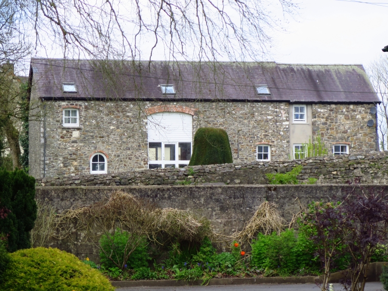
Late C18 or early C19 barn, now house, marked on 1837 Tithe Map. The farm was then owned by Elizabeth Edwards of Rhydygors and occupied by Simon Thomas. Earlier it had been leased from the Edwinsford estate by Charles Nott, father of Major-General Sir William Nott, who came to Carmarthen in 1794 as landlord of the Ivy Bush Hotel.
Detached former barn, now house, in rubble stone (whitewashed when listed in 1981) with red brick dressings and slate gabled roof. Irregular 2 storey. Tall cambered-arched centre barn entries on long walls, infilled with late C20 glazing. One ventilation slot to right on E side, 2 on W side. E side has cambered-headed 4-pane sash to first floor left, then ground floor small 4-pane arched window. To right of barn door are 2 ground floor 4-pane sashes with cambered brick heads and slate sills. Three flush C20 skylights. Blank left gable end to road.
The right end had outside steps rising up between barn and a rubble outbuilding to right with flat-arched entry in front wall. Now much rebuilt in late C20 with recessed one-window rendered section to left with 4-pane sash each floor (presumably on site of stair), and rebuilt rubble stone section to right with one ground floor 4-pane sash with cambered brick head.
Included despite alterations as a traditional agricultural building of group value with the former farmhouse at Pontgarreg.
External links are from the relevant listing authority and, where applicable, Wikidata. Wikidata IDs may be related buildings as well as this specific building. If you want to add or update a link, you will need to do so by editing the Wikidata entry.


Other nearby listed buildings
