Approximate Location Map
Large Map »
Latitude: 51.776 / 51°46'33"N
Longitude: -4.462 / 4°27'43"W
OS Eastings: 230243
OS Northings: 211458
OS Grid: SN302114
Mapcode National: GBR D7.ZCVY
Mapcode Global: VH3LS.LMZD
Plus Code: 9C3QQGGQ+96
Entry Name: Churchyard at St. Martin's Parish
Listing Date: 25 September 1986
Last Amended: 25 September 1986
Grade: II
Source: Cadw
Source ID: 9624
Building Class: Religious, Ritual and Funerary
ID on this website: 300009624
Location: Old churchyard on northern outskirts of Town Centre bounded to N and E by rubble walls.
County: Carmarthenshire
Community: Laugharne Township (Treflan Lacharn)
Community: Laugharne Township
Built-Up Area: Laugharne
Traditional County: Carmarthenshire
Tagged with: Churchyard
Retains a particularly fine collection of C18 and C19 monuments, including some marble and of classical style. Steps up to E with a 2-tier terrace, rubble revetment walls and further monuments. Funerary vaults exist beneath lower terrace, one with segmental voussoir arched entrance (blocked) has inscribed stone reading. "The Family Vault of Robert Holderness Esq. Laugharne 1873".
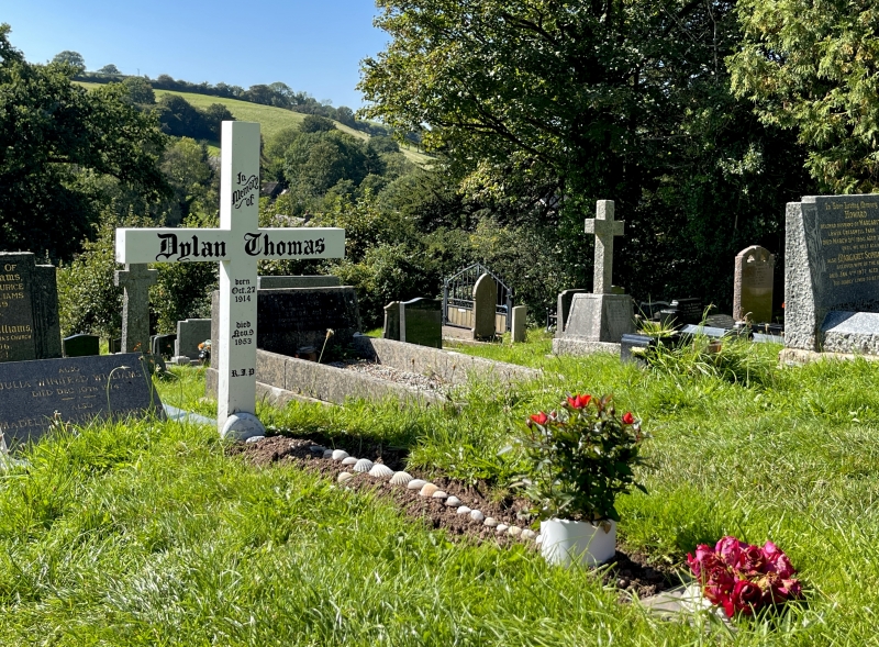
In the new churchyard there is a simple wooden cross at the grave of Dylan Thomas, died 1953.
Group value.
External links are from the relevant listing authority and, where applicable, Wikidata. Wikidata IDs may be related buildings as well as this specific building. If you want to add or update a link, you will need to do so by editing the Wikidata entry.


Other nearby listed buildings
